IMAGES TAKEN NEAR TO
St. Brides Close, BOLTON, BL6 7TD
Introduction
This page details the photographs taken nearby to St. Brides Close, BL6 7TD by members of the Geograph project.
The Geograph project started in 2005 with the aim of publishing, organising and preserving representative images for every square kilometre of Great Britain, Ireland and the Isle of Man.

There are currently over 7.5m images from over14,400 individuals and you can help contribute to the project by visiting https://www.geograph.org.uk
Image Map
Images are licensed for reuse under creativecommons.org/licenses/by-sa/2.0
Notes
- Clicking on the map will re-center to the selected point.
- The higher the marker number, the further away the image location is from the centre of the postcode.
Image Listing (63 Images Found)
Images are licensed for reuse under creativecommons.org/licenses/by-sa/2.0
Image
Details
Distance
2
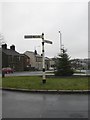
Horwich, fingerpost
Good to see the survival of a traditional fingerpost at the junction of A673 and B5238; this specimen was made by the Royal Label Factory.
Image: © Mike Faherty
Taken: 13 Jan 2011
0.07 miles

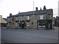
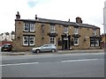
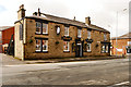
5
The Toll Bar Inn on Chorley New Road, Horwich
http://www.geograph.org.uk/photo/4493785
Image: © Ian S
Taken: 25 May 2015
0.08 miles
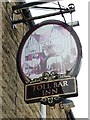
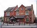
6
The Toll Bar Inn on Chorley New Road, Horwich
http://www.geograph.org.uk/photo/4493790
Image: © Ian S
Taken: 25 May 2015
0.08 miles
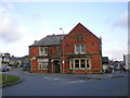
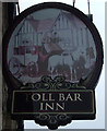
10
Toll Bar Inn, Chorley New Road, Horwich
Image: © David Dixon
Taken: 2 Mar 2016
0.09 miles