IMAGES TAKEN NEAR TO
Dryfield Lane, BOLTON, BL6 7RT
Introduction
This page details the photographs taken nearby to Dryfield Lane, BL6 7RT by members of the Geograph project.
The Geograph project started in 2005 with the aim of publishing, organising and preserving representative images for every square kilometre of Great Britain, Ireland and the Isle of Man.

There are currently over 7.5m images from over14,400 individuals and you can help contribute to the project by visiting https://www.geograph.org.uk
Image Map
Images are licensed for reuse under creativecommons.org/licenses/by-sa/2.0
Notes
- Clicking on the map will re-center to the selected point.
- The higher the marker number, the further away the image location is from the centre of the postcode.
Image Listing (10 Images Found)
Images are licensed for reuse under creativecommons.org/licenses/by-sa/2.0
Image
Details
Distance
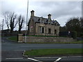
2
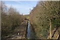
Water channel below Lower Rivington Reservoir
Image: © Mark Anderson
Taken: 24 Feb 2018
0.13 miles
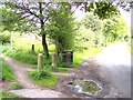
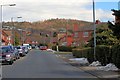
5
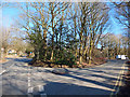
Junction of Rivington Lane and Ryfield Lane
Image: © Gary Rogers
Taken: 25 Feb 2018
0.22 miles
6
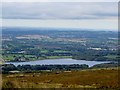
Lower Rivington Reservoir
Looking south west from the slopes of Winter Hill.
Image: © philandju
Taken: 19 Sep 2016
0.23 miles
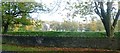
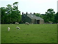
10
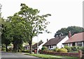
Suburban bungalows
On Lever Park Avenue in Horwich.
Image: © philandju
Taken: 24 Aug 2020
0.25 miles