IMAGES TAKEN NEAR TO
Green Lane, BOLTON, BL6 7ND
Introduction
This page details the photographs taken nearby to Green Lane, BL6 7ND by members of the Geograph project.
The Geograph project started in 2005 with the aim of publishing, organising and preserving representative images for every square kilometre of Great Britain, Ireland and the Isle of Man.

There are currently over 7.5m images from over14,400 individuals and you can help contribute to the project by visiting https://www.geograph.org.uk
Image Map (Loading...)


Getting Data...Please wait
Leaflet Map data © OpenStreetMap
Images are licensed for reuse under creativecommons.org/licenses/by-sa/2.0
Notes
- Clicking on the map will re-center to the selected point.
- The higher the marker number, the further away the image location is from the centre of the postcode.
Image Listing (58 Images Found)
Images are licensed for reuse under creativecommons.org/licenses/by-sa/2.0
Image
Details
Distance
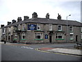
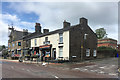
1
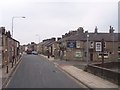
Horwich: junction of Darley Street and Catherine St East
View of the junction with the towering view of The Pike in the distance.
Image: © Mr Eugene Birchall
Taken: 18 Feb 2005
0.08 miles
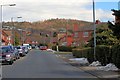
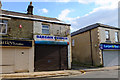
2
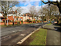
Suburban bungalows
On Lever Park Avenue in Horwich.
Image: © philandju
Taken: 24 Aug 2020
0.11 miles
4
The Bowling Green on Lee Lane Horwich
Image: © Raymond Knapman
Taken: 26 Jul 2012
0.15 miles