IMAGES TAKEN NEAR TO
Berwyn Close, BOLTON, BL6 7BW
Introduction
This page details the photographs taken nearby to Berwyn Close, BL6 7BW by members of the Geograph project.
The Geograph project started in 2005 with the aim of publishing, organising and preserving representative images for every square kilometre of Great Britain, Ireland and the Isle of Man.

There are currently over 7.5m images from over14,400 individuals and you can help contribute to the project by visiting https://www.geograph.org.uk
Image Map
Images are licensed for reuse under creativecommons.org/licenses/by-sa/2.0
Notes
- Clicking on the map will re-center to the selected point.
- The higher the marker number, the further away the image location is from the centre of the postcode.
Image Listing (17 Images Found)
Images are licensed for reuse under creativecommons.org/licenses/by-sa/2.0
Image
Details
Distance
2
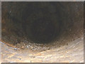
Old mine shaft in Wilderswood
There are many old coal and clay mine workings in the vicinity of Wilderswood and higher up on Winter Hill. This one was well hidden with a capping and only located by a knowledgeable friend pointing it out. No exact position given to protect the curious or the just plain stupid.
Image: © Karl and Ali
Taken: 29 Jun 2014
0.15 miles
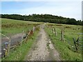
3
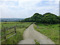
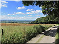
Farm track near Ormston's Farm
Rivington reservoir seen in distance
Image: © Raymond Knapman
Taken: 15 Aug 2016
0.18 miles
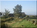
5
Track below Ormstons Farm with view towards Lower Rivington Reservoir
Image: © Colin Park
Taken: 12 Aug 2015
0.19 miles
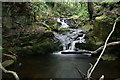
8
Shaw's Wood
Shaw's Cough running through Shaw's Wood.
Image: © Peter McDermott
Taken: 9 Apr 2017
0.19 miles
9
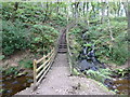
Footbridge and steps in Shaw's Clough
Image: © Raymond Knapman
Taken: 15 Aug 2016
0.20 miles
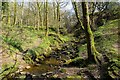
10
Footpath from Ormstons Farm to Wilderswood
Image: © Oliver Dixon
Taken: 2 Aug 2021
0.22 miles