IMAGES TAKEN NEAR TO
Wilderswood, BOLTON, BL6 6SB
Introduction
This page details the photographs taken nearby to Wilderswood, BL6 6SB by members of the Geograph project.
The Geograph project started in 2005 with the aim of publishing, organising and preserving representative images for every square kilometre of Great Britain, Ireland and the Isle of Man.

There are currently over 7.5m images from over14,400 individuals and you can help contribute to the project by visiting https://www.geograph.org.uk
Image Map
Images are licensed for reuse under creativecommons.org/licenses/by-sa/2.0
Notes
- Clicking on the map will re-center to the selected point.
- The higher the marker number, the further away the image location is from the centre of the postcode.
Image Listing (21 Images Found)
Images are licensed for reuse under creativecommons.org/licenses/by-sa/2.0
Image
Details
Distance
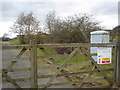
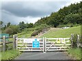
2
Hidden footpath marker on Foxholes Road
The grit bin marks the start of the path to Ormston's Farm
Image: © Raymond Knapman
Taken: 15 Aug 2016
0.12 miles
3
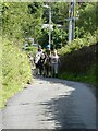
Horses on Factory Hill
An outing from the Foxfields Therapeutic Riding Centre for disabled children and children with special educational needs.
Image: © Oliver Dixon
Taken: 2 Aug 2021
0.14 miles
4
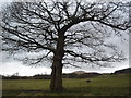
Oak tree near Wilderswood
Looking North towards Rivington Pike.
Image: © Margaret Clough
Taken: 16 Feb 2006
0.15 miles
5
Wilderswood
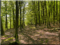
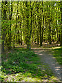
Wilderswood (Wilder’s Wood) is a heavily wooded area on the southern flank of Winter Hill, south of George's Lane, near Rivington Pike. Up until the second half of the twentieth century, Wilder's Wood was much smaller than it is today, being mainly confined to the area of Wilder's Clough (http://wtp2.appspot.com/wheresthepath.htm?lat=53.59846231682764&lon=-2.531308309629222&gz=14&oz=8>=6. – present day and historical map). The bulk of the area was once bare moorland with few trees (except for the nearby wooded cloughs) and would have been fairly busy with local coal mining activities.There was also a large house known as “Rockhaven Castle” which was demolished in 1942, possibly because it provided an ideal marker for German bombers trying to target the Loco works in Horwich (http://www.about-horwich.co.uk/horwich/about-horwich-Rockhaven_Castle.html About Horwich - includes a photograph of the castle in its heyday).
The larger area now covered by Wilderswood was planted with Beech, Alder, Corsican and Lodgepole pines in 1959 in an agreement between Lancashire County Council and Blackrod Urban District Council. Hybrid Larch was planted later to replace dead pines.
http://www.daveweb.co.uk/whcombined.pdf Winter Hill Scrapbook compiled by Dave Lane
http://justramblingon.co.uk/country-walks/rivington/to-the-wilderswood/ “To The Wilderswood” - Mal Firth “Just Rambling On”
Image: © David Dixon
Taken: 22 May 2012
0.17 miles
6
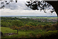
The view from the Wilderswood car park
The Reebok Stadium can be seen in the distance
Image: © Ian Greig
Taken: 13 May 2011
0.19 miles
8
Wilderswood
Wilderswood (Wilder’s Wood) is a heavily wooded area on the southern flank of Winter Hill, south of George's Lane, near Rivington Pike. Up until the second half of the twentieth century, Wilder's Wood was much smaller than it is today, being mainly confined to the area of Wilder's Clough (http://wtp2.appspot.com/wheresthepath.htm?lat=53.59846231682764&lon=-2.531308309629222&gz=14&oz=8>=6. – present day and historical map). The bulk of the area was once bare moorland with few trees (except for the nearby wooded cloughs) and would have been fairly busy with local coal mining activities.There was also a large house known as “Rockhaven Castle” which was demolished in 1942, possibly because it provided an ideal marker for German bombers trying to target the Loco works in Horwich (http://www.about-horwich.co.uk/horwich/about-horwich-Rockhaven_Castle.html About Horwich - includes a photograph of the castle in its heyday).
The larger area now covered by Wilderswood was planted with Beech, Alder, Corsican and Lodgepole pines in 1959 in an agreement between Lancashire County Council and Blackrod Urban District Council. Hybrid Larch was planted later to replace dead pines.
http://www.daveweb.co.uk/whcombined.pdf Winter Hill Scrapbook compiled by Dave Lane
http://justramblingon.co.uk/country-walks/rivington/to-the-wilderswood/ “To The Wilderswood” - Mal Firth “Just Rambling On”
Image: © David Dixon
Taken: 22 May 2012
0.19 miles
9
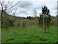
Marklands Reservoir Memorial Forest
Woodland managed by United Utilities where people may pay for the planting of a tree in memory of a deceased loved one. Ashes may be sprinkled among the roots of the tree at the time of planting.
Image: © philandju
Taken: 23 Apr 2018
0.20 miles
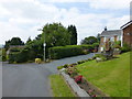
10
Water supply installation beside Factory Hill
Image: © Oliver Dixon
Taken: 2 Aug 2021
0.20 miles