IMAGES TAKEN NEAR TO
Matchmoor Lane, BOLTON, BL6 6PW
Introduction
This page details the photographs taken nearby to Matchmoor Lane, BL6 6PW by members of the Geograph project.
The Geograph project started in 2005 with the aim of publishing, organising and preserving representative images for every square kilometre of Great Britain, Ireland and the Isle of Man.

There are currently over 7.5m images from over14,400 individuals and you can help contribute to the project by visiting https://www.geograph.org.uk
Image Map (Loading...)


Getting Data...Please wait
Leaflet Map data © OpenStreetMap
Images are licensed for reuse under creativecommons.org/licenses/by-sa/2.0
Notes
- Clicking on the map will re-center to the selected point.
- The higher the marker number, the further away the image location is from the centre of the postcode.
Image Listing (9 Images Found)
Images are licensed for reuse under creativecommons.org/licenses/by-sa/2.0
Image
Details
Distance
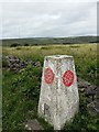
3

Old Harpers Trig Point Flush Bracket S2798
Image: © thejackrustles
Taken: 21 Jul 2022
0.10 miles
4
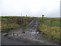
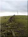
Footpaths off Matchmoor Lane
The finger post on the right shows a path to Slack Hall. The post on the left indicates a path running along the top of Burnt Edge, past Old Harpers Farm and on towards Adam Hill.
Image: © philandju
Taken: 9 Jan 2012
0.16 miles
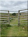
6
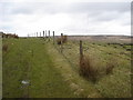
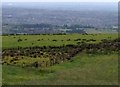
Moorland path off Matchmoor Lane
Looking North towards Winter Hill.
Image: © Margaret Clough
Taken: 16 Feb 2006
0.17 miles
7
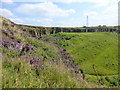
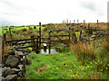
Montcliffe Stone Quarry
Old workings of the quarry returning to nature. Peregrine Falcons seen overhead at this point.
Image: © Raymond Knapman
Taken: 15 Aug 2016
0.19 miles