IMAGES TAKEN NEAR TO
Chorley New Road, BOLTON, BL6 6HR
Introduction
This page details the photographs taken nearby to Chorley New Road, BL6 6HR by members of the Geograph project.
The Geograph project started in 2005 with the aim of publishing, organising and preserving representative images for every square kilometre of Great Britain, Ireland and the Isle of Man.

There are currently over 7.5m images from over14,400 individuals and you can help contribute to the project by visiting https://www.geograph.org.uk
Image Map
Images are licensed for reuse under creativecommons.org/licenses/by-sa/2.0
Notes
- Clicking on the map will re-center to the selected point.
- The higher the marker number, the further away the image location is from the centre of the postcode.
Image Listing (25 Images Found)
Images are licensed for reuse under creativecommons.org/licenses/by-sa/2.0
Image
Details
Distance
1
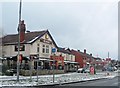
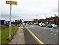
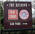
Chorley New Road (A673), Horwich
Between the Beehive Roundabout and Maple Avenue.
Image: © David Dixon
Taken: 25 Sep 2010
0.05 miles
2
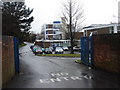
Entrance gates to St Joseph's RC High School
Image: © Anthony Parkes
Taken: 20 Jan 2013
0.06 miles
3
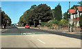
Chorley New Road, Horwich
Pedestrian traffic lights, near to Maple Avenue.
Image: © David Dixon
Taken: 25 Sep 2010
0.07 miles
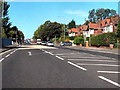
4
Chorley New Road
The A673 towards Horwich.
Image: © Gerald England
Taken: 24 Sep 2016
0.08 miles
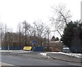
5
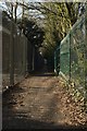
Footpath off Chorley New Road
This footpath heads south to Mansell Way.
Image: © Mark Anderson
Taken: 25 Feb 2018
0.08 miles
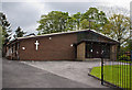
8
St. Joseph's R.C. High School and Sports College
Image: © Margaret Clough
Taken: 16 Jan 2006
0.13 miles
9
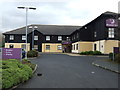
Premier Inn Bolton West Hotel
On Chorley New Road (A673).
Image: © JThomas
Taken: 28 Mar 2015
0.14 miles