IMAGES TAKEN NEAR TO
Chorley New Road, BOLTON, BL6 6EX
Introduction
This page details the photographs taken nearby to Chorley New Road, BL6 6EX by members of the Geograph project.
The Geograph project started in 2005 with the aim of publishing, organising and preserving representative images for every square kilometre of Great Britain, Ireland and the Isle of Man.

There are currently over 7.5m images from over14,400 individuals and you can help contribute to the project by visiting https://www.geograph.org.uk
Image Map
Images are licensed for reuse under creativecommons.org/licenses/by-sa/2.0
Notes
- Clicking on the map will re-center to the selected point.
- The higher the marker number, the further away the image location is from the centre of the postcode.
Image Listing (15 Images Found)
Images are licensed for reuse under creativecommons.org/licenses/by-sa/2.0
Image
Details
Distance
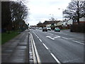
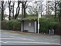
1
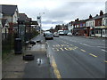
Bus stop and shelter on Chorley New Road (A673)
Someone seems to have fly-tipped their unwanted tyres.
Image: © JThomas
Taken: 28 Mar 2015
0.12 miles
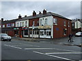
3
Hair & Beauty Salon
On Chorley New Road (A673).
Image: © JThomas
Taken: 28 Mar 2015
0.14 miles
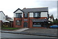
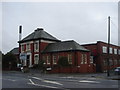
5
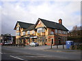
The Greenwood Arms, Chorley New Road
Image: © Alexander P Kapp
Taken: 25 Mar 2009
0.14 miles
6
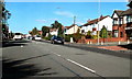
Chorley New Road (A673), Horwich
The pedestrian lights, just after the junction with Ainsworth Avenue.
Image: © David Dixon
Taken: 25 Sep 2010
0.15 miles
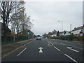
7
Chorley New Road (A673)
Heading north west.
Image: © JThomas
Taken: 28 Mar 2015
0.17 miles
8
'Chortex' Victoria Mill, Horwich
Building at the entrance on Chorley New Road.
Image: © Margaret Clough
Taken: 16 Jan 2006
0.17 miles
9
Bus stop and shelter on Chorley New Road (A673)
Image: © JThomas
Taken: 28 Mar 2015
0.18 miles