IMAGES TAKEN NEAR TO
Belgrave Crescent, BOLTON, BL6 6DG
Introduction
This page details the photographs taken nearby to Belgrave Crescent, BL6 6DG by members of the Geograph project.
The Geograph project started in 2005 with the aim of publishing, organising and preserving representative images for every square kilometre of Great Britain, Ireland and the Isle of Man.

There are currently over 7.5m images from over14,400 individuals and you can help contribute to the project by visiting https://www.geograph.org.uk
Image Map
Images are licensed for reuse under creativecommons.org/licenses/by-sa/2.0
Notes
- Clicking on the map will re-center to the selected point.
- The higher the marker number, the further away the image location is from the centre of the postcode.
Image Listing (17 Images Found)
Images are licensed for reuse under creativecommons.org/licenses/by-sa/2.0
Image
Details
Distance
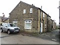
2
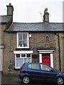
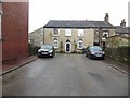
Old Post Office, Horwich
1801 is marked on a plaque on the wall. It is now a cottage.
Image: © Margaret Clough
Taken: 16 Jan 2006
0.19 miles
4
The Old Chapel, Horwich
At the end of Chapel Street, the house was once a chapel.
Image: © philandju
Taken: 14 Jan 2014
0.20 miles
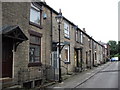
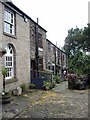
5
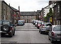
Chapel Street, Horwich
Stone cottages across the road from the C.of E. parish church
Image: © Phil and Juliette Platt
Taken: 17 Jun 2011
0.20 miles
6
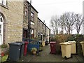
Bin day at George Street
Recycling bins awaiting attention in Horwich.
Image: © philandju
Taken: 14 Jan 2014
0.21 miles
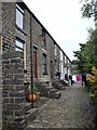
8
Stone cottages in Horwich
Off Chapel Street.
Image: © philandju
Taken: 14 Jan 2014
0.22 miles
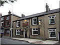
9
George St, Nos 3-11, Horwich
The building at the left is the former chapel facing down Chapel St.
Image: © John Lord
Taken: 25 Jun 2011
0.22 miles