IMAGES TAKEN NEAR TO
Fleet Street, BOLTON, BL6 6BB
Introduction
This page details the photographs taken nearby to Fleet Street, BL6 6BB by members of the Geograph project.
The Geograph project started in 2005 with the aim of publishing, organising and preserving representative images for every square kilometre of Great Britain, Ireland and the Isle of Man.

There are currently over 7.5m images from over14,400 individuals and you can help contribute to the project by visiting https://www.geograph.org.uk
Image Map
Images are licensed for reuse under creativecommons.org/licenses/by-sa/2.0
Notes
- Clicking on the map will re-center to the selected point.
- The higher the marker number, the further away the image location is from the centre of the postcode.
Image Listing (3 Images Found)
Images are licensed for reuse under creativecommons.org/licenses/by-sa/2.0
Image
Details
Distance
1
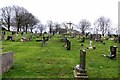
Ridgmont Cemetery, Horwich
Local Authority cemetery near Horwich. The large cross monument on the skyline is a memorial to the Redemptorists, a society of Catholic missionary priests founded by St. Alphonsus Maria Ligouri in 1732. Missions to Catholic parishes in England formed a large part of the society's work in the early and mid twentieth century. Sermons by the Redemptorist Fathers during these mission weeks to poor Catholic parishes were often noted for their "hell fire and brimstone" content.
Image: © philandju
Taken: 30 Jan 2014
0.11 miles
2

Ridgmont Cemetery (Horwich)
Chorley Old Road, Horwich. First Interment was on 5th March 1928
Image: © Mr Eugene Birchall
Taken: 18 May 2010
0.17 miles
3
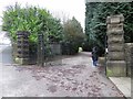
Entrance to Ridgmont Cemetery
A local authority cemetery near Horwich.
Image: © philandju
Taken: 30 Jan 2014
0.24 miles