IMAGES TAKEN NEAR TO
Fernstone Close, BOLTON, BL6 5TX
Introduction
This page details the photographs taken nearby to Fernstone Close, BL6 5TX by members of the Geograph project.
The Geograph project started in 2005 with the aim of publishing, organising and preserving representative images for every square kilometre of Great Britain, Ireland and the Isle of Man.

There are currently over 7.5m images from over14,400 individuals and you can help contribute to the project by visiting https://www.geograph.org.uk
Image Map (Loading...)


Getting Data...Please wait
Leaflet Map data © OpenStreetMap
Images are licensed for reuse under creativecommons.org/licenses/by-sa/2.0
Notes
- Clicking on the map will re-center to the selected point.
- The higher the marker number, the further away the image location is from the centre of the postcode.
Image Listing (20 Images Found)
Images are licensed for reuse under creativecommons.org/licenses/by-sa/2.0
Image
Details
Distance
1

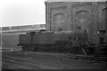
View From Horwich Works
Looking across the works sidings towards Chorley New Road and, beyond, Holy Trinity Church on Church Street. The wagons on the left are standing on what was the line into Horwich station, which closed in 1965 following the Beeching Report.
The church in the photo is Horwich Parish Church. The Chimney was part of the Pickup Toilet factory and was demolished by Fred Dibnah not long after the photo was taken - info supplied by Flickr contact jampot2.
Image: © Martin Addison
Taken: Unknown
0.13 miles
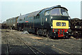
2
Ex LMS 2-6-4 tank 42359, Horwich Works ? 1963
This was the first version of the 2-6-4T type for the LMS, very much in Derby/Midland Railway style. The type was completely redeveloped with taper boiler and improved cab after Stanier joined the LMS.
Image: © Alan Murray-Rust
Taken: Unknown
0.14 miles
3
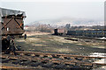
View From Horwich Works
Looking from the sidings of the works across the rooftops of Horwich towards Rivington Pike. The building in the centre behind the trees is on the corner of Winter Hey Lane and Chorley New Road.
Image: © Martin Addison
Taken: Unknown
0.14 miles
4
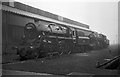
43140 at Horwich Works ? 1963
Ivatt Class 4 2-6-0 developed for the LMS in 1947. The very utilitarian appearance gained them a variety of nicknames. The one I was familiar with was 'nut 'n bolter'. The design developed into the slightly less spartan BR Standard class 4 http://www.geograph.org.uk/photo/6465016 .
Image: © Alan Murray-Rust
Taken: Unknown
0.15 miles
5
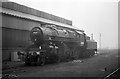
Locomotives at Horwich Works ? 1963
BR Standard class 4 2-6-0 76024 in the foreground with former LMS class 4 2-6-0 43140 beyond. The BR loco was essentially the LMS loco but designed with fittings common to the other BR Standard locomotive classes.
Image: © Alan Murray-Rust
Taken: Unknown
0.15 miles
6
Western Lady at Horwich
A preserved Class 52 locomotive, D1048 'Western Lady' spent from late 1980 until 83 stored in Horwich Works during a move from the North Yorkshire Moors Railway to her current home at the Midland Railway Centre. I believe there was also a change of ownership involved.
The Western's were built for the Western Region of British Railways and were Diesel Hydraulic locomotives. The majority of locomotives built for BR were of Diesel Electric type and when rationalisation was carried out to remove a surplus of locomotives the Hydraulics were deemed non-standard. D1048 entered service in December 1962 and was withdrawn in February 1977.
Image: © Martin Addison
Taken: Unknown
0.17 miles
7
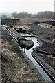
Horwich Works Drainage System
Looking almost like a canal in miniature, a set of stone channels and sluices guide water leaving the works through a series of filters to remove oil contamination before it passes to a small reservoir beyond the fence.
Image: © Martin Addison
Taken: Unknown
0.17 miles

9
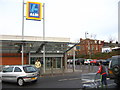
Aldi - Horwich
Aldi supermarket sits on the west side Chorley New Road and is accessed via Mason Street.
Image: © John Tustin
Taken: 13 Feb 2009
0.20 miles
10
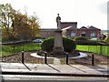
War Memorial at Horwich
Cenotaph to the fallen of the First World war, adjacent to the Fire station on Chorley New Road.
Image: © Roger May
Taken: 7 Nov 2005
0.21 miles