IMAGES TAKEN NEAR TO
Langstone Close, BOLTON, BL6 5SZ
Introduction
This page details the photographs taken nearby to Langstone Close, BL6 5SZ by members of the Geograph project.
The Geograph project started in 2005 with the aim of publishing, organising and preserving representative images for every square kilometre of Great Britain, Ireland and the Isle of Man.

There are currently over 7.5m images from over14,400 individuals and you can help contribute to the project by visiting https://www.geograph.org.uk
Image Map
Images are licensed for reuse under creativecommons.org/licenses/by-sa/2.0
Notes
- Clicking on the map will re-center to the selected point.
- The higher the marker number, the further away the image location is from the centre of the postcode.
Image Listing (27 Images Found)
Images are licensed for reuse under creativecommons.org/licenses/by-sa/2.0
Image
Details
Distance
1
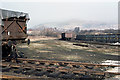
View From Horwich Works
Looking from the sidings of the works across the rooftops of Horwich towards Rivington Pike. The building in the centre behind the trees is on the corner of Winter Hey Lane and Chorley New Road.
Image: © Martin Addison
Taken: Unknown
0.06 miles
2
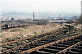
View From Horwich Works
Looking across the works sidings towards Chorley New Road and, beyond, Holy Trinity Church on Church Street. The wagons on the left are standing on what was the line into Horwich station, which closed in 1965 following the Beeching Report.
The church in the photo is Horwich Parish Church. The Chimney was part of the Pickup Toilet factory and was demolished by Fred Dibnah not long after the photo was taken - info supplied by Flickr contact jampot2.
Image: © Martin Addison
Taken: Unknown
0.07 miles
3
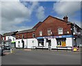
Aldi - Horwich
Aldi supermarket sits on the west side Chorley New Road and is accessed via Mason Street.
Image: © John Tustin
Taken: 13 Feb 2009
0.11 miles
4
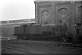
Ex LMS 2-6-4 tank 42359, Horwich Works ? 1963
This was the first version of the 2-6-4T type for the LMS, very much in Derby/Midland Railway style. The type was completely redeveloped with taper boiler and improved cab after Stanier joined the LMS.
Image: © Alan Murray-Rust
Taken: Unknown
0.13 miles
6
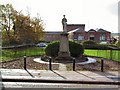
War Memorial at Horwich
Cenotaph to the fallen of the First World war, adjacent to the Fire station on Chorley New Road.
Image: © Roger May
Taken: 7 Nov 2005
0.14 miles
9
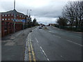
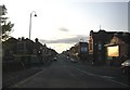
Chorley New Road (A673)
Heading north west.
Image: © JThomas
Taken: 28 Mar 2015
0.15 miles