IMAGES TAKEN NEAR TO
Barker De Lane, BOLTON, BL6 5SP
Introduction
This page details the photographs taken nearby to Barker De Lane, BL6 5SP by members of the Geograph project.
The Geograph project started in 2005 with the aim of publishing, organising and preserving representative images for every square kilometre of Great Britain, Ireland and the Isle of Man.

There are currently over 7.5m images from over14,400 individuals and you can help contribute to the project by visiting https://www.geograph.org.uk
Image Map (Loading...)


Getting Data...Please wait
Leaflet Map data © OpenStreetMap
Images are licensed for reuse under creativecommons.org/licenses/by-sa/2.0
Notes
- Clicking on the map will re-center to the selected point.
- The higher the marker number, the further away the image location is from the centre of the postcode.
Image Listing (12 Images Found)
Images are licensed for reuse under creativecommons.org/licenses/by-sa/2.0
Image
Details
Distance
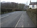
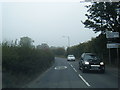
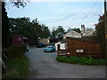
2
Public footpath sign on Scot Lane
Blackrod industrial estate signed for turn to right of view
Image: © Raymond Knapman
Taken: 3 Jun 2011
0.03 miles
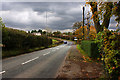
7
B5238 Scot Lane at Bolton (Blackrod) boundary
Image: © Colin Pyle
Taken: 3 Oct 2015
0.10 miles
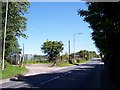
8
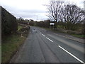
Welcome to Bolton
Heading north east on Scot Lane (B5238).
Image: © JThomas
Taken: 28 Mar 2015
0.11 miles
10
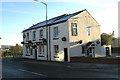
The Poacher at Scot Lane Ends, Blackrod
Image: © David Long
Taken: 18 Nov 2005
0.22 miles