IMAGES TAKEN NEAR TO
Victoria Road, BOLTON, BL6 5PE
Introduction
This page details the photographs taken nearby to Victoria Road, BL6 5PE by members of the Geograph project.
The Geograph project started in 2005 with the aim of publishing, organising and preserving representative images for every square kilometre of Great Britain, Ireland and the Isle of Man.

There are currently over 7.5m images from over14,400 individuals and you can help contribute to the project by visiting https://www.geograph.org.uk
Image Map
Images are licensed for reuse under creativecommons.org/licenses/by-sa/2.0
Notes
- Clicking on the map will re-center to the selected point.
- The higher the marker number, the further away the image location is from the centre of the postcode.
Image Listing (15 Images Found)
Images are licensed for reuse under creativecommons.org/licenses/by-sa/2.0
Image
Details
Distance
5
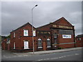
Former tramsheds and waiting-room, Horwich
Image: © John Lord
Taken: 25 Jun 2011
0.14 miles
6
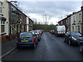
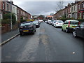
Stephenson Street, Horwich
Looking south west.
Image: © JThomas
Taken: 28 Mar 2015
0.18 miles
7
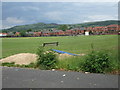
Horwich RMI Cricket Club
Horwich RMI CC's Ramsbottom Road ground with Rivington Pike in the background.
The club have two teams in the Bolton Cricket League and a third team in the marvellously named Horwich Churches and Welfare Cricket Association.
Image: © BatAndBall
Taken: 20 Jun 2012
0.21 miles
9
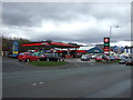
Service station on Chorley New Road (A673)
Unleaded 113.9p.
Diesel 119.9p.
Image: © JThomas
Taken: 28 Mar 2015
0.22 miles