IMAGES TAKEN NEAR TO
Chorley New Road, BOLTON, BL6 5NN
Introduction
This page details the photographs taken nearby to Chorley New Road, BL6 5NN by members of the Geograph project.
The Geograph project started in 2005 with the aim of publishing, organising and preserving representative images for every square kilometre of Great Britain, Ireland and the Isle of Man.

There are currently over 7.5m images from over14,400 individuals and you can help contribute to the project by visiting https://www.geograph.org.uk
Image Map
Images are licensed for reuse under creativecommons.org/licenses/by-sa/2.0
Notes
- Clicking on the map will re-center to the selected point.
- The higher the marker number, the further away the image location is from the centre of the postcode.
Image Listing (26 Images Found)
Images are licensed for reuse under creativecommons.org/licenses/by-sa/2.0
Image
Details
Distance
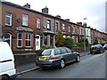
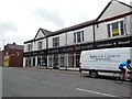
3
Stephenson Street, Horwich
Looking south west.
Image: © JThomas
Taken: 28 Mar 2015
0.07 miles
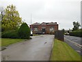
5
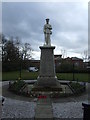
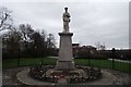
War Memorial at Horwich Loco Works
On Chorley New Road, Horwich.
Image: © Ian S
Taken: 24 May 2015
0.13 miles
7
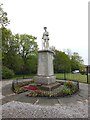
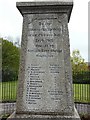
War Memorial, Horwich
On the site of the now demolished Horwich Loco Works, the re-furbished memorial lists the names of those men of Horwich who lost their lives in The Great War and the Second World War.
Image: © philandju
Taken: 28 Apr 2013
0.13 miles
9
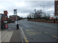
Bus stop on Chorley New Road (A673), Horwich
Image: © JThomas
Taken: 28 Mar 2015
0.14 miles