IMAGES TAKEN NEAR TO
Chorley Road, BOLTON, BL6 5LQ
Introduction
This page details the photographs taken nearby to Chorley Road, BL6 5LQ by members of the Geograph project.
The Geograph project started in 2005 with the aim of publishing, organising and preserving representative images for every square kilometre of Great Britain, Ireland and the Isle of Man.

There are currently over 7.5m images from over14,400 individuals and you can help contribute to the project by visiting https://www.geograph.org.uk
Image Map (Loading...)


Getting Data...Please wait
Leaflet Map data © OpenStreetMap
Images are licensed for reuse under creativecommons.org/licenses/by-sa/2.0
Notes
- Clicking on the map will re-center to the selected point.
- The higher the marker number, the further away the image location is from the centre of the postcode.
Image Listing (17 Images Found)
Images are licensed for reuse under creativecommons.org/licenses/by-sa/2.0
Image
Details
Distance
2

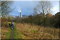
Steaming chimneys on Huyton Road
An interesting assortment of chimneys on a textile dyeing and printing works, all busily belching steam on a grey autumn day.
Image: © Antony Dixon
Taken: 28 Sep 2012
0.17 miles
3
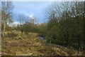
Footpath
Footpath into Adlington. The old bleachworks factory chimney is in the background.
Image: © Galatas
Taken: 26 Jan 2011
0.17 miles
4
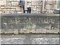
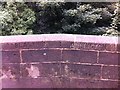
Old Boundary Marker
Bridge Marker between the two parts of LA_MACY18bpb on the east parapet of Waterhouse Bridge, on the A6 Chorley Road. On the boundary of Adlington and Blackrod parishes. Inscribed C. C. WATERHOUSE BRIDGE. See also https://www.geograph.org.uk/photo/6093766.
Milestone Society National ID: LA_MACY18br
Image: © W MacDonald
Taken: 21 Feb 2020
0.18 miles
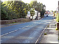
5
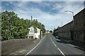
Waterhouse Bridge
This bridge carrying the A6 road is marked to show the boundary between Blackrod and Adlington. The inscription shows that Adlington was a constituent of the Leyland Hundred and Blackrod the Salford Hundred. Salford? That's miles away - unlike the stone buildings of Pin Croft textile dyeing and printing mill, one of the last operating textile businesses to survive in Lancashire.
Image: © David Hignett
Taken: 9 Sep 2005
0.18 miles
7
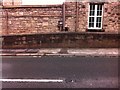
Old Boundary Marker by the A6, Waterhouse Bridge, Adlington
Parish Boundary Marker by the A6, in parish of Adlington (Chorley District), Chorley Road, Waterhouse Bridge, just North of junction with Douglas View.
Inscription reads:-
LEYLAND HUNDRED C.C.WATERHOUSE BRIDGE SALFORD HUNDRED
Surveyed
Milestone Society National ID: LA_MACY18bpb
Image: © Milestone Society
Taken: Unknown
0.18 miles
9
Old Boundary Marker by the A6, Waterhouse Bridge, Chorley Road, Adlington parish
Parish Boundary Marker by the A6, in parish of Adlington (Chorley District), Chorley Road, centre of Waterhouse Bridge, just North of junction with Douglas View, West side of road.
Inscription reads:-
BLACKROD | ADLINGTON
Surveyed
Milestone Society National ID: LA_MACY18apb
Image: © Milestone Society
Taken: Unknown
0.19 miles