IMAGES TAKEN NEAR TO
Chorley Road, BOLTON, BL6 5LA
Introduction
This page details the photographs taken nearby to Chorley Road, BL6 5LA by members of the Geograph project.
The Geograph project started in 2005 with the aim of publishing, organising and preserving representative images for every square kilometre of Great Britain, Ireland and the Isle of Man.

There are currently over 7.5m images from over14,400 individuals and you can help contribute to the project by visiting https://www.geograph.org.uk
Image Map (Loading...)


Getting Data...Please wait
Leaflet Map data © OpenStreetMap
Images are licensed for reuse under creativecommons.org/licenses/by-sa/2.0
Notes
- Clicking on the map will re-center to the selected point.
- The higher the marker number, the further away the image location is from the centre of the postcode.
Image Listing (13 Images Found)
Images are licensed for reuse under creativecommons.org/licenses/by-sa/2.0
Image
Details
Distance
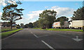
1
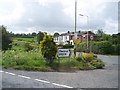
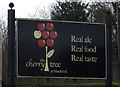
The Cherry Tree at Blackrod
On Chorley Road (A6).
Image: © JThomas
Taken: 28 Mar 2015
0.00 miles
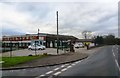
2
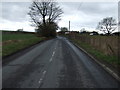
Chorley Road (A6)
Heading south east towards Wigan.
Image: © JThomas
Taken: 28 Mar 2015
0.02 miles
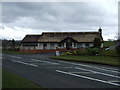
4
A6 Chorley Road
The A6, north of Blackrod, just after passing Blackrod Brow.
Image: © David Dixon
Taken: 29 Aug 2010
0.05 miles
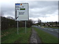
5

Chorley Road (A6)
The A6 between Blackrod and Adlington. Approaching the crossroads with Dark Lane on the left and Grimeford Lane on the right.
Image: © David Dixon
Taken: 29 Aug 2010
0.05 miles
7
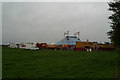
Circus in field beside the A6 at Blackrod
Image: © David Long
Taken: 22 Sep 2009
0.10 miles
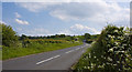
9
Grimeford Lane
Heading south west towards the A6.
Image: © JThomas
Taken: 28 Mar 2015
0.12 miles