IMAGES TAKEN NEAR TO
Blackrod By Pass, BOLTON, BL6 5JH
Introduction
This page details the photographs taken nearby to Blackrod By Pass, BL6 5JH by members of the Geograph project.
The Geograph project started in 2005 with the aim of publishing, organising and preserving representative images for every square kilometre of Great Britain, Ireland and the Isle of Man.

There are currently over 7.5m images from over14,400 individuals and you can help contribute to the project by visiting https://www.geograph.org.uk
Image Map (Loading...)


Getting Data...Please wait
Leaflet Map data © OpenStreetMap
Images are licensed for reuse under creativecommons.org/licenses/by-sa/2.0
Notes
- Clicking on the map will re-center to the selected point.
- The higher the marker number, the further away the image location is from the centre of the postcode.
Image Listing (25 Images Found)
Images are licensed for reuse under creativecommons.org/licenses/by-sa/2.0
Image
Details
Distance
1

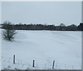
A6 Blackrod Bypass
The A6 to the north of Blackrod.
Image: © David Dixon
Taken: 29 Aug 2010
0.09 miles
3
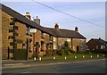
Poolgreen, Blackrod
Poolgreen is a strip of cottages in Blackrod, in the Metropolitan Borough of Bolton, in Greater Manchester, England.
Image: © Steven Haslington
Taken: 22 Mar 2015
0.14 miles

5
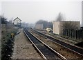
Blackrod Junction and signalbox
Blackrod Junction still survives, though the line from Horwich works in the photo is now (2008) no more. The box was sometimes termed the "standing joke" by railwaymen, as its survival into the 1990s was solely due to the inability of electronics at Preston signalbox (built 1973) to exchange train ID data with those at Manchester North (built circa 1990). To achieve the necessary exchange of information, the signalman at Blackrod receives information from one super-duper modern signalbox and manually re-enters it into the system feeding the other. Ain't technology wonderful?
Image: © Peter Whatley
Taken: 9 Feb 1989
0.15 miles
6
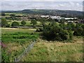
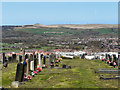
From Blackrod Cemetery
The road is the A6. Horwich is in the middle ground. Rivington Pike is in the background.
Image: © philandju
Taken: 14 Aug 2013
0.17 miles
7
Blackrod Cemetery
Blackrod Cemetery, overlooking Winter Hill.
Image: © David Dixon
Taken: 8 Apr 2011
0.19 miles
8
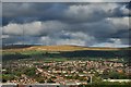
View from Blackrod cemetery
View to Winter Hill from Blackrod cemetery
Image: © Galatas
Taken: 23 Sep 2009
0.20 miles
9
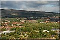
View from graveyard at Blackrod cemetery
View to Horwich from graveyard at Blackrod cemetery
Image: © Galatas
Taken: 23 Sep 2009
0.21 miles
10
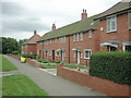
Council Houses
Vicarage Road is part of a large estate housing the residents of Blackrod
Image: © David Hignett
Taken: 8 Sep 2005
0.21 miles