IMAGES TAKEN NEAR TO
Ainse Road, BOLTON, BL6 5HA
Introduction
This page details the photographs taken nearby to Ainse Road, BL6 5HA by members of the Geograph project.
The Geograph project started in 2005 with the aim of publishing, organising and preserving representative images for every square kilometre of Great Britain, Ireland and the Isle of Man.

There are currently over 7.5m images from over14,400 individuals and you can help contribute to the project by visiting https://www.geograph.org.uk
Image Map (Loading...)


Getting Data...Please wait
Leaflet Map data © OpenStreetMap
Images are licensed for reuse under creativecommons.org/licenses/by-sa/2.0
Notes
- Clicking on the map will re-center to the selected point.
- The higher the marker number, the further away the image location is from the centre of the postcode.
Image Listing (24 Images Found)
Images are licensed for reuse under creativecommons.org/licenses/by-sa/2.0
Image
Details
Distance
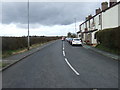
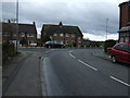
1
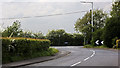
The junction with Dark Lane is right on a bend
Image: © Ian Greig
Taken: 6 May 2011
0.06 miles
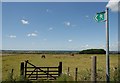
4
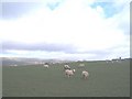
Sheep in Little Scotland
A view of Winter Hill and Blackrod Church from Little Scotland.
Image: © Paul Bennett
Taken: 18 Mar 2007
0.10 miles
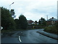
5
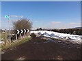
Dark Lane, Blackrod
Still blocked by last week's snowfall.
Image: © Bryan Pready
Taken: 29 Mar 2013
0.13 miles
8
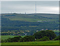
View towards Winter Hill
The hill is 1,496 ft (456 m) above sea level, the transmitter mast is 309.48 metres (1,015.4 ft) in height, making it the highest television transmitting antenna in the United Kingdom.
Image: © Mat Fascione
Taken: 16 Jul 2016
0.16 miles
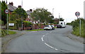
10

Sign for the Hilltops Sports & Social Club
Image: © JThomas
Taken: 28 Mar 2015
0.17 miles