IMAGES TAKEN NEAR TO
Church Street, BOLTON, BL6 5EE
Introduction
This page details the photographs taken nearby to Church Street, BL6 5EE by members of the Geograph project.
The Geograph project started in 2005 with the aim of publishing, organising and preserving representative images for every square kilometre of Great Britain, Ireland and the Isle of Man.

There are currently over 7.5m images from over14,400 individuals and you can help contribute to the project by visiting https://www.geograph.org.uk
Image Map
Images are licensed for reuse under creativecommons.org/licenses/by-sa/2.0
Notes
- Clicking on the map will re-center to the selected point.
- The higher the marker number, the further away the image location is from the centre of the postcode.
Image Listing (30 Images Found)
Images are licensed for reuse under creativecommons.org/licenses/by-sa/2.0
Image
Details
Distance
2

Blackrod National and Sunday School
Datestone set in the side of the wall bounding the front churchyard of Image
Image: © David Dixon
Taken: 8 Apr 2011
0.04 miles
3
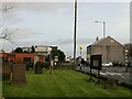
Blackrod
View from outside St Katharine Church.
Image: © Richard Webb
Taken: 7 Nov 2021
0.04 miles
4
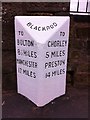
Old Milestone by the B5408, Church Street, Blackrod Parish
Carved stone post by the B5408 (was A6), in parish of BLACKROD (BOLTON District), Church Street, Blackrod, by Red Lion, on East side of road. Lancs CC stone triangle, erected by the County Council in the 19th/20th century.
Inscription reads:-
: TO / BOLTON / 8½ MILES / MANCHESTER / 17 MILES : : BLACKROD : : TO / CHORLEY / 5 MILES / PRESTON / 14 MILES :
Milestone Society National ID: LA_MACY17.
Image: © J Higgins
Taken: 1 Oct 2008
0.05 miles
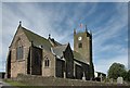
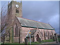
5
St Katharine Church, Blackrod
St Katharine Church, Blackrod, 161 metres, a P48 hill.
The Parish Church of St. Katharine stands in a prominent position in the village of Blackrod and can be seen from many miles around. The first history of the church is lost in obscurity and the date of the birth of the original church is unknown. It goes back further than any known authentic records. There is evidence of settlement in the area since before Roman Britain. Blackrod stands on an ancient Roman road, an important route from London to the North, and it is widely believed that a Roman Fort was built here. Situated on high ground with a good view of surrounding countryside, it would have been in an ideal position. Frieslanders who came as mercenaries with the Roman army settled in Blackrod giving it the Friesian name Blech-rode meaning cold and barren land. The village became an important stop for travellers in medieval times and later merchants came regularly from Manchester to supply yarn to the local handloom weavers. It was once a major coal mining centre with at least seven pits in the village and over a thousand miners living and working locally. The earliest records of mining date from the 1500s. The highest recorded population of the 1800s was in 1881, when there were 4,234 people in Blackrod. In 1992 there were approximately 7,000 residents.
Image: © Rude Health
Taken: 4 Feb 2012
0.05 miles
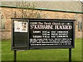
7
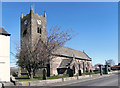
The Parish Church of Saint Katharine Blackrod
The Parish Church of St. Katharine stands in a prominent position in the village of Blackrod and can be seen from many miles around. The Church is dedicated to Saint Katharine of Alexandria. There are several variations of the spelling of her name but the old original, with a 'K' and two 'A's, is the one used here.
The first recorded evidence of a church in Blackrod is in the Manchester Diocesan Calendar which says that a church existed in 1138. Most of the present church was rebuilt in the early 1900s, replacing an earlier church. The oldest part of the church is the lower tower which was part of a church built during the reign of Elizabeth I.
http://www.stkatharine.net/history.php - St Katharine’s church website
Image: © David Dixon
Taken: 8 Apr 2011
0.05 miles
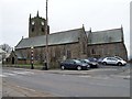
8

St Katharine's Parish Church, Blackrod
The Parish Church of St. Katharine stands in a prominent position in the village of Blackrod and can be seen from many miles around. The Church is dedicated to Saint Katharine of Alexandria. There are several variations of the spelling of her name but the old original, with a 'K' and two 'A's, is the one used here.
The first recorded evidence of a church in Blackrod is in the Manchester Diocesan Calendar which says that a church existed in 1138. Most of the present church was rebuilt in the early 1900s, replacing an earlier church. The oldest part of the church is the lower tower which was part of a church built during the reign of Elizabeth I.
http://www.stkatharine.net/history.php - St Katharine’s church website
Image: © David Dixon
Taken: 8 Apr 2011
0.05 miles
10
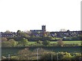
St Katherine's Church, Blackrod
This view is taken from the nearby Rivington Services on the M61 Motorway. Being on high ground, St Katherine's Church is visible for many a mile.
Image: © Terry Robinson
Taken: 16 May 2012
0.06 miles