IMAGES TAKEN NEAR TO
Whitehall Lane, BOLTON, BL6 5DR
Introduction
This page details the photographs taken nearby to Whitehall Lane, BL6 5DR by members of the Geograph project.
The Geograph project started in 2005 with the aim of publishing, organising and preserving representative images for every square kilometre of Great Britain, Ireland and the Isle of Man.

There are currently over 7.5m images from over14,400 individuals and you can help contribute to the project by visiting https://www.geograph.org.uk
Image Map (Loading...)


Getting Data...Please wait
Leaflet Map data © OpenStreetMap
Images are licensed for reuse under creativecommons.org/licenses/by-sa/2.0
Notes
- Clicking on the map will re-center to the selected point.
- The higher the marker number, the further away the image location is from the centre of the postcode.
Image Listing (12 Images Found)
Images are licensed for reuse under creativecommons.org/licenses/by-sa/2.0
Image
Details
Distance

2

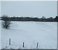
A6 Blackrod Bypass
The A6 to the north of Blackrod.
Image: © David Dixon
Taken: 29 Aug 2010
0.09 miles
4
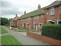
Council Houses
Vicarage Road is part of a large estate housing the residents of Blackrod
Image: © David Hignett
Taken: 8 Sep 2005
0.16 miles
5
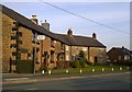
Poolgreen, Blackrod
Poolgreen is a strip of cottages in Blackrod, in the Metropolitan Borough of Bolton, in Greater Manchester, England.
Image: © Steven Haslington
Taken: 22 Mar 2015
0.18 miles
8
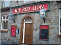
Entrance to The Red Lion on Church Street
Image: © Raymond Knapman
Taken: 23 May 2011
0.20 miles
9
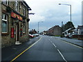
The Red Lion, Blackrod
The Red Lion public house on Church Street, Blackrod.
Image: © David Dixon
Taken: 8 Apr 2011
0.20 miles
10
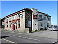
The Red Lion, Blackrod
The Red Lion public house on Church Street, Blackrod.
Image: © David Dixon
Taken: 8 Apr 2011
0.20 miles