IMAGES TAKEN NEAR TO
Whitehall Lane, BOLTON, BL6 5DQ
Introduction
This page details the photographs taken nearby to Whitehall Lane, BL6 5DQ by members of the Geograph project.
The Geograph project started in 2005 with the aim of publishing, organising and preserving representative images for every square kilometre of Great Britain, Ireland and the Isle of Man.

There are currently over 7.5m images from over14,400 individuals and you can help contribute to the project by visiting https://www.geograph.org.uk
Image Map
Images are licensed for reuse under creativecommons.org/licenses/by-sa/2.0
Notes
- Clicking on the map will re-center to the selected point.
- The higher the marker number, the further away the image location is from the centre of the postcode.
Image Listing (27 Images Found)
Images are licensed for reuse under creativecommons.org/licenses/by-sa/2.0
Image
Details
Distance
2
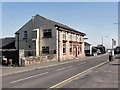
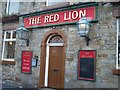
The Red Lion, Blackrod
The Red Lion public house on Church Street, Blackrod.
Image: © David Dixon
Taken: 8 Apr 2011
0.12 miles
3
The Red Lion, Blackrod
The Red Lion public house on Church Street, Blackrod.
Image: © David Dixon
Taken: 8 Apr 2011
0.12 miles
4
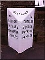
Old Milestone by the B5408, Church Street, Blackrod Parish
Carved stone post by the B5408 (was A6), in parish of BLACKROD (BOLTON District), Church Street, Blackrod, by Red Lion, on East side of road. Lancs CC stone triangle, erected by the County Council in the 19th/20th century.
Inscription reads:-
: TO / BOLTON / 8½ MILES / MANCHESTER / 17 MILES : : BLACKROD : : TO / CHORLEY / 5 MILES / PRESTON / 14 MILES :
Milestone Society National ID: LA_MACY17.
Image: © J Higgins
Taken: 1 Oct 2008
0.12 miles
5
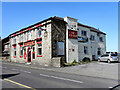
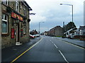
Entrance to The Red Lion on Church Street
Image: © Raymond Knapman
Taken: 23 May 2011
0.12 miles
9
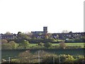
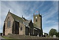
St Katherine's Church, Blackrod
This view is taken from the nearby Rivington Services on the M61 Motorway. Being on high ground, St Katherine's Church is visible for many a mile.
Image: © Terry Robinson
Taken: 16 May 2012
0.17 miles
10
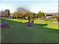
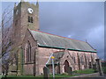
St Katharine's Churchyard
The churchyard at the rear of Image The churchyard was closed for burials in 1881, excepting family graves and vaults. It was grassed over in 1973, and many of the older headstones were removed or buried.
(http://www.stkatharine.net/history.php - St Katharine's church website)
Image: © David Dixon
Taken: 8 Apr 2011
0.17 miles