IMAGES TAKEN NEAR TO
Meadow Way, BOLTON, BL6 5BR
Introduction
This page details the photographs taken nearby to Meadow Way, BL6 5BR by members of the Geograph project.
The Geograph project started in 2005 with the aim of publishing, organising and preserving representative images for every square kilometre of Great Britain, Ireland and the Isle of Man.

There are currently over 7.5m images from over14,400 individuals and you can help contribute to the project by visiting https://www.geograph.org.uk
Image Map (Loading...)


Getting Data...Please wait
Leaflet Map data © OpenStreetMap
Images are licensed for reuse under creativecommons.org/licenses/by-sa/2.0
Notes
- Clicking on the map will re-center to the selected point.
- The higher the marker number, the further away the image location is from the centre of the postcode.
Image Listing (4 Images Found)
Images are licensed for reuse under creativecommons.org/licenses/by-sa/2.0
Image
Details
Distance
1
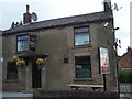
Barristers on Manchester Road in Blackrod
Image: © Raymond Knapman
Taken: 23 May 2011
0.04 miles
2
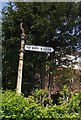
Old Direction Sign - Signpost by the B5408, Manchester Road, Blackrod
Annulus finial - 1 Worboys arm; Blackrod halo by the B5408, in parish of Blackrod (Bolton District), Manchester Road junction with Station Road (B5238 north), North West corner of junction.
Surveyed
Milestone Society National ID: LA_SD6210.
Image: © Philip Platt
Taken: Unknown
0.11 miles