IMAGES TAKEN NEAR TO
Lynstock Way, BOLTON, BL6 4SA
Introduction
This page details the photographs taken nearby to Lynstock Way, BL6 4SA by members of the Geograph project.
The Geograph project started in 2005 with the aim of publishing, organising and preserving representative images for every square kilometre of Great Britain, Ireland and the Isle of Man.

There are currently over 7.5m images from over14,400 individuals and you can help contribute to the project by visiting https://www.geograph.org.uk
Image Map
Images are licensed for reuse under creativecommons.org/licenses/by-sa/2.0
Notes
- Clicking on the map will re-center to the selected point.
- The higher the marker number, the further away the image location is from the centre of the postcode.
Image Listing (9 Images Found)
Images are licensed for reuse under creativecommons.org/licenses/by-sa/2.0
Image
Details
Distance
3
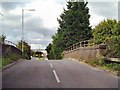
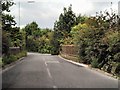
Lostock Lane Bridge
Bridge carrying Lostock Lane over the railway.
Image: © David Dixon
Taken: 29 Aug 2010
0.14 miles
5
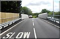
Lostock Lane
Bridge crossing Middle Brook.
Image: © David Dixon
Taken: 29 Aug 2010
0.19 miles
6
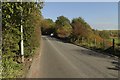
Lostock Lane approaching the bridges
The road crosses Middle Brook and then the railway line.
Image: © Mark Anderson
Taken: 20 Oct 2018
0.19 miles
7
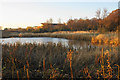
Pond near Lostock
The result of poor drainage. Lostock Office Park is behind. This is viewed in autumn afternoon light.
Image: © Bill Boaden
Taken: 17 Nov 2018
0.22 miles
8

Footpath to Wingates
Crossing scrub in the valley of Middle Brook on a late afternoon in autumn.
Image: © Bill Boaden
Taken: 17 Nov 2018
0.24 miles
9

Woodland near Lostock
There were some deer ahead but I was not quick enough to photograph them.
Image: © Bill Boaden
Taken: 17 Nov 2018
0.24 miles