IMAGES TAKEN NEAR TO
Kilworth Drive, BOLTON, BL6 4RP
Introduction
This page details the photographs taken nearby to Kilworth Drive, BL6 4RP by members of the Geograph project.
The Geograph project started in 2005 with the aim of publishing, organising and preserving representative images for every square kilometre of Great Britain, Ireland and the Isle of Man.

There are currently over 7.5m images from over14,400 individuals and you can help contribute to the project by visiting https://www.geograph.org.uk
Image Map (Loading...)


Getting Data...Please wait
Leaflet Map data © OpenStreetMap
Images are licensed for reuse under creativecommons.org/licenses/by-sa/2.0
Notes
- Clicking on the map will re-center to the selected point.
- The higher the marker number, the further away the image location is from the centre of the postcode.
Image Listing (9 Images Found)
Images are licensed for reuse under creativecommons.org/licenses/by-sa/2.0
Image
Details
Distance
2
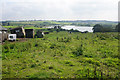
Grazing for cows above Rumworth Lodge Reservoir
Looking down the slope from Junction Road West.
Image: © Bill Boaden
Taken: 8 Sep 2015
0.13 miles
3
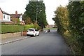
Kilworth Drive, Lostock Junction
A new housing development down quite a steep hill off Junction Road West, offering a view of the moors to the north.
Image: © Bill Boaden
Taken: 8 Sep 2015
0.18 miles
4
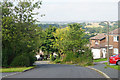
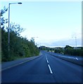
The A58 Beaumont Road
I can remember when this was cobbled. They were very late putting a modern surface on what was possibly one of the earliest bypasses or ring roads in the country.
Image: © Ian Greig
Taken: 8 Jun 2012
0.18 miles
5
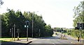
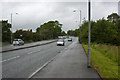
The turning onto Armadale Road
From Beaumont Road.
Image: © philandju
Taken: 31 Jul 2020
0.19 miles

8
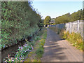
Middle Brook
The path along Middle Brook. Heaton Bridge can be seen ahead.
Image: © David Dixon
Taken: 1 Sep 2011
0.23 miles
9
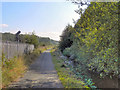
Middle Brook
The path alongside Middle Brook. The railway is behind the fence to the left; the top of the signal is visible above the line of the fence.
Image: © David Dixon
Taken: 1 Sep 2011
0.25 miles