IMAGES TAKEN NEAR TO
High Rid Lane, BOLTON, BL6 4LH
Introduction
This page details the photographs taken nearby to High Rid Lane, BL6 4LH by members of the Geograph project.
The Geograph project started in 2005 with the aim of publishing, organising and preserving representative images for every square kilometre of Great Britain, Ireland and the Isle of Man.

There are currently over 7.5m images from over14,400 individuals and you can help contribute to the project by visiting https://www.geograph.org.uk
Image Map
Images are licensed for reuse under creativecommons.org/licenses/by-sa/2.0
Notes
- Clicking on the map will re-center to the selected point.
- The higher the marker number, the further away the image location is from the centre of the postcode.
Image Listing (5 Images Found)
Images are licensed for reuse under creativecommons.org/licenses/by-sa/2.0
Image
Details
Distance
1
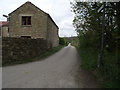
High Rid Farm and un-named lane
The lane is a public footpath leading to Wilson Fold and then on to join Chorley Old Road at Bottom o'th' Moor.
Image: © Phil Platt
Taken: 13 Apr 2011
0.17 miles
2
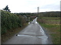
Track to Bottom o' th' moor
Looking north near High Rid Farm.
Image: © JThomas
Taken: 28 Mar 2015
0.19 miles
3
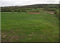
Farmland to the west of High Rid reservoir
The reservoir's western embankment is just out of shot to the right.
Image: © Phil Platt
Taken: 13 Apr 2011
0.24 miles
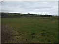
5
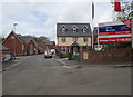
New houses at Fall Birch
Built on the site of the now demolished Fall Birch Hospital, the development is called "Silver Birches".
Image: © Phil Platt
Taken: 13 Apr 2011
0.25 miles