IMAGES TAKEN NEAR TO
St. Johns Road, BOLTON, BL6 4HD
Introduction
This page details the photographs taken nearby to St. Johns Road, BL6 4HD by members of the Geograph project.
The Geograph project started in 2005 with the aim of publishing, organising and preserving representative images for every square kilometre of Great Britain, Ireland and the Isle of Man.

There are currently over 7.5m images from over14,400 individuals and you can help contribute to the project by visiting https://www.geograph.org.uk
Image Map
Images are licensed for reuse under creativecommons.org/licenses/by-sa/2.0
Notes
- Clicking on the map will re-center to the selected point.
- The higher the marker number, the further away the image location is from the centre of the postcode.
Image Listing (13 Images Found)
Images are licensed for reuse under creativecommons.org/licenses/by-sa/2.0
Image
Details
Distance
1
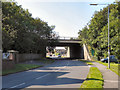
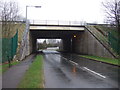
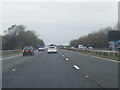
St John's Road, Motorway Bridge
The bridge carrying the M61 motorway over St John's Road at Chew Moor.
Image: © David Dixon
Taken: 1 Sep 2011
0.07 miles
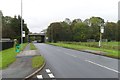
2
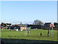
Tempest A.F.C.
Football pitch and playground near Chew Moor. It has been home to Tempest amateur football club since 1946.
Image: © Roger May
Taken: 28 Dec 2005
0.07 miles

5
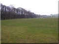
Farmland beside the M61 Motorway
Off Chew Moor Lane.
Image: © JThomas
Taken: 28 Mar 2015
0.10 miles
8
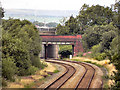
Bridges
Looking north, along the railway track, from Manchester Road. The first bridge is carrying a narrow lane. Behind it, is the M61 motorway.
Image: © David Dixon
Taken: 29 Aug 2010
0.16 miles
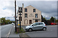
10
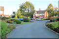
Copperfields, Chew Moor
This is one corner in the group of cul-de-sacs known as Copperfields.
Image: © Geoff Royle
Taken: 10 Oct 2010
0.19 miles