IMAGES TAKEN NEAR TO
Lostock Lane, BOLTON, BL6 4FU
Introduction
This page details the photographs taken nearby to Lostock Lane, BL6 4FU by members of the Geograph project.
The Geograph project started in 2005 with the aim of publishing, organising and preserving representative images for every square kilometre of Great Britain, Ireland and the Isle of Man.

There are currently over 7.5m images from over14,400 individuals and you can help contribute to the project by visiting https://www.geograph.org.uk
Image Map
Images are licensed for reuse under creativecommons.org/licenses/by-sa/2.0
Notes
- Clicking on the map will re-center to the selected point.
- The higher the marker number, the further away the image location is from the centre of the postcode.
Image Listing (8 Images Found)
Images are licensed for reuse under creativecommons.org/licenses/by-sa/2.0
Image
Details
Distance
5

Pond by Lostock Hall
A relic of former activity on land that is now being largely developed for housing. A footpath runs on the other side.
Image: © Bill Boaden
Taken: 17 Nov 2018
0.22 miles
7
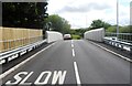
Lostock Lane Bridge
Bridge carrying Lostock Lane over the railway.
Image: © David Dixon
Taken: 29 Aug 2010
0.22 miles
8

Woodland near Lostock
There were some deer ahead but I was not quick enough to photograph them.
Image: © Bill Boaden
Taken: 17 Nov 2018
0.25 miles