IMAGES TAKEN NEAR TO
Lostock Lane, BOLTON, BL6 4BL
Introduction
This page details the photographs taken nearby to Lostock Lane, BL6 4BL by members of the Geograph project.
The Geograph project started in 2005 with the aim of publishing, organising and preserving representative images for every square kilometre of Great Britain, Ireland and the Isle of Man.

There are currently over 7.5m images from over14,400 individuals and you can help contribute to the project by visiting https://www.geograph.org.uk
Image Map
Images are licensed for reuse under creativecommons.org/licenses/by-sa/2.0
Notes
- Clicking on the map will re-center to the selected point.
- The higher the marker number, the further away the image location is from the centre of the postcode.
Image Listing (8 Images Found)
Images are licensed for reuse under creativecommons.org/licenses/by-sa/2.0
Image
Details
Distance
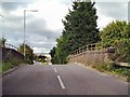
3
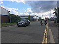
Cranfield Road
Industrial estate road on the western edge of Bolton.
Image: © David Lally
Taken: 20 Jul 2017
0.18 miles
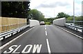
7
Lostock Lane Bridge
Bridge carrying Lostock Lane over the railway.
Image: © David Dixon
Taken: 29 Aug 2010
0.23 miles
8
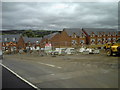
Lostock Cricket Club - New Development
The new housing development at Lostock CC's old Lostock Lane ground.
The club is awaiting a new ground at Chew Moor Lane and currently play their "home" fixtures at Haydock CC.
Lostock run two teams in the Manchester & District Cricket Association.
Image: © BatAndBall
Taken: 16 Aug 2012
0.24 miles