IMAGES TAKEN NEAR TO
Chorley Road, BOLTON, BL5 3NL
Introduction
This page details the photographs taken nearby to Chorley Road, BL5 3NL by members of the Geograph project.
The Geograph project started in 2005 with the aim of publishing, organising and preserving representative images for every square kilometre of Great Britain, Ireland and the Isle of Man.

There are currently over 7.5m images from over14,400 individuals and you can help contribute to the project by visiting https://www.geograph.org.uk
Image Map
Images are licensed for reuse under creativecommons.org/licenses/by-sa/2.0
Notes
- Clicking on the map will re-center to the selected point.
- The higher the marker number, the further away the image location is from the centre of the postcode.
Image Listing (15 Images Found)
Images are licensed for reuse under creativecommons.org/licenses/by-sa/2.0
Image
Details
Distance
1
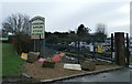
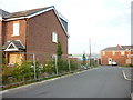
Entrance to Baxter's Landscape Supplies
Image: © Anthony Parkes
Taken: 7 Jan 2016
0.06 miles
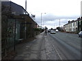
5
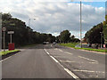
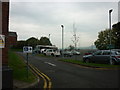
Chorley Road (A6)
The A6 approaching Blackrod. (Between Baxters Nursery and the Ramada Jarvis Hotel)
Image: © David Dixon
Taken: 29 Aug 2010
0.09 miles
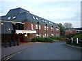
6
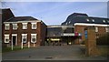
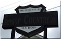
Bolton Georgian House Hotel
The Bolton Georgian House Hotel is a Mercure hotel on the outskirts of Blackrod in Greater Manchester, England.
Image: © Steven Haslington
Taken: 22 Mar 2015
0.10 miles