IMAGES TAKEN NEAR TO
Chorley Road, BOLTON, BL5 3NA
Introduction
This page details the photographs taken nearby to Chorley Road, BL5 3NA by members of the Geograph project.
The Geograph project started in 2005 with the aim of publishing, organising and preserving representative images for every square kilometre of Great Britain, Ireland and the Isle of Man.

There are currently over 7.5m images from over14,400 individuals and you can help contribute to the project by visiting https://www.geograph.org.uk
Image Map
Images are licensed for reuse under creativecommons.org/licenses/by-sa/2.0
Notes
- Clicking on the map will re-center to the selected point.
- The higher the marker number, the further away the image location is from the centre of the postcode.
Image Listing (15 Images Found)
Images are licensed for reuse under creativecommons.org/licenses/by-sa/2.0
Image
Details
Distance

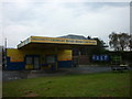
3
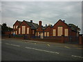
The India Gate
Indian restaurant on Chorley Road (A6), Four Gates.
Image: © JThomas
Taken: 28 Mar 2015
0.10 miles
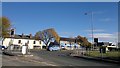
4
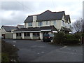
The India Gate Restaurant
On the A6 Chorley Road.
Image: © Mark Anderson
Taken: 20 Oct 2018
0.10 miles
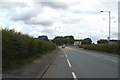
5
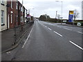
Chorley Road (A6), Four Gates
Heading south east.
Image: © JThomas
Taken: 28 Mar 2015
0.15 miles
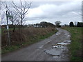
8
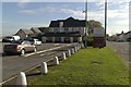
Cooper Turning, Westhoughton
Cooper Turning is a suburban hamlet on the outskirts of Westhoughton, Greater Manchester, formed at the junction of Chorley Road (the A6 road) and Dicconson Lane.
Image: © Steven Haslington
Taken: 5 Nov 2012
0.20 miles
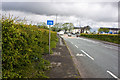
9
Junction of Dicconson Lane (B5239) with the A6
It's not a match day today.
Image: © David Long
Taken: 18 Jun 2009
0.20 miles
10
The traffic light junction at Cooper Turning on the A6
Image: © Ian Greig
Taken: 11 May 2012
0.21 miles