IMAGES TAKEN NEAR TO
West Halt Drive, BL5 3LH
Introduction
This page details the photographs taken nearby to West Halt Drive, BL5 3LH by members of the Geograph project.
The Geograph project started in 2005 with the aim of publishing, organising and preserving representative images for every square kilometre of Great Britain, Ireland and the Isle of Man.

There are currently over 7.5m images from over14,400 individuals and you can help contribute to the project by visiting https://www.geograph.org.uk
Image Map
Images are licensed for reuse under creativecommons.org/licenses/by-sa/2.0
Notes
- Clicking on the map will re-center to the selected point.
- The higher the marker number, the further away the image location is from the centre of the postcode.
Image Listing (8 Images Found)
Images are licensed for reuse under creativecommons.org/licenses/by-sa/2.0
Image
Details
Distance
2
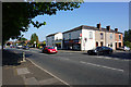
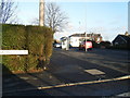
Corner shop on Park Road
On the corner of Park Road and Platt Lane.
Image: © Bill Boaden
Taken: 8 Sep 2015
0.19 miles
3
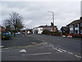
Park Road, Westhoughton
Park Road north east of its junction with Waters Nook Road
Image: © Alexander P Kapp
Taken: 12 Feb 2008
0.20 miles
4
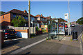
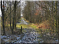
Footpath leaving Park Road
Conveniently by a bus stop. It is now a route through a housing estate.
Image: © Bill Boaden
Taken: 8 Sep 2015
0.20 miles
7
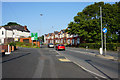
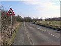
The A58 nearing Chequerbent Roundabout
The roundabout is a busy one, being the junction of the A58 and the A6. At certain times of the day, the traffic is queuing back here.
Image: © Bill Boaden
Taken: 8 Sep 2015
0.24 miles
8
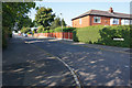
Waters Nook Road
Giving access to housing in the eastward expansion of Westhoughton.
Image: © Bill Boaden
Taken: 8 Sep 2015
0.25 miles