IMAGES TAKEN NEAR TO
Hindley Road, BOLTON, BL5 2TG
Introduction
This page details the photographs taken nearby to Hindley Road, BL5 2TG by members of the Geograph project.
The Geograph project started in 2005 with the aim of publishing, organising and preserving representative images for every square kilometre of Great Britain, Ireland and the Isle of Man.

There are currently over 7.5m images from over14,400 individuals and you can help contribute to the project by visiting https://www.geograph.org.uk
Image Map
Images are licensed for reuse under creativecommons.org/licenses/by-sa/2.0
Notes
- Clicking on the map will re-center to the selected point.
- The higher the marker number, the further away the image location is from the centre of the postcode.
Image Listing (9 Images Found)
Images are licensed for reuse under creativecommons.org/licenses/by-sa/2.0
Image
Details
Distance
2

Grounds of Mere Hall
The lawns are turning brown after a rainless period.
Image: © philandju
Taken: 20 Jul 2018
0.15 miles
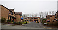
3
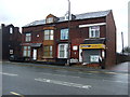
Shop and houses on Chorley Old Road (B6226)
Image: © JThomas
Taken: 28 Mar 2015
0.20 miles
4
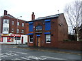
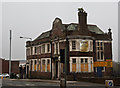
The Nelson, Bolton
Public house on Chorley Old Road (B6226).
Image: © JThomas
Taken: 28 Mar 2015
0.20 miles
5
Chayah House Clinic
Bolton Healing Rooms, a centre for alternative healing.
Image: © Bill Boaden
Taken: 15 Sep 2012
0.21 miles
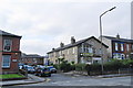
6

Bus stop and shelter on Chorley Old Road (B6226)
Image: © JThomas
Taken: 28 Mar 2015
0.21 miles
7
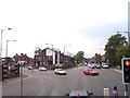
Chorley New Road joins Chorley Old Road at Bolton
New Road on the left, Old Road straight on
Image: © Raymond Knapman
Taken: 26 Jul 2012
0.21 miles
9
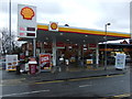
Service station on Chorley Old Road (B6226)
Image: © JThomas
Taken: 28 Mar 2015
0.25 miles