IMAGES TAKEN NEAR TO
Bank Field, BOLTON, BL5 2QG
Introduction
This page details the photographs taken nearby to Bank Field, BL5 2QG by members of the Geograph project.
The Geograph project started in 2005 with the aim of publishing, organising and preserving representative images for every square kilometre of Great Britain, Ireland and the Isle of Man.

There are currently over 7.5m images from over14,400 individuals and you can help contribute to the project by visiting https://www.geograph.org.uk
Image Map
Images are licensed for reuse under creativecommons.org/licenses/by-sa/2.0
Notes
- Clicking on the map will re-center to the selected point.
- The higher the marker number, the further away the image location is from the centre of the postcode.
Image Listing (8 Images Found)
Images are licensed for reuse under creativecommons.org/licenses/by-sa/2.0
Image
Details
Distance
1
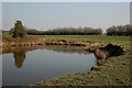
Pond above Hall Lee Bank park, Westhoughton
The fields on the E side of the park contain several small ponds, used by local anglers.
Image: © Jim Barton
Taken: 8 Mar 2011
0.13 miles
3
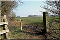
Fields near Water's Nook, Westhoughton
There were several small farms in this area some years ago. Some fields have been built over, but a few like this still remain.
Image: © Jim Barton
Taken: 8 Mar 2011
0.14 miles
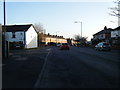
4
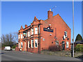
Rosehill Tavern
The Rosehill tavern on Leigh Road (B5235), near Daisy Hill Station.
Image: © David Dixon
Taken: 8 Feb 2012
0.19 miles
5
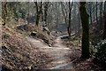
Footpath in Hall Lee Bank Park, Westhoughton
Image: © ray blow
Taken: 27 Dec 2007
0.19 miles
6
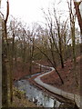
Paths in Hall Lee Bank park, Westhoughton
This small park follows a wooded valley S towards Daisy Hill.
Image: © Jim Barton
Taken: 8 Mar 2011
0.22 miles
7
Hall Lee Bank Park, Westhoughton
Park Road entrance.
Image: © Margaret Clough
Taken: 11 Jan 2006
0.23 miles