IMAGES TAKEN NEAR TO
Roundthorn Lane, BOLTON, BL5 2PQ
Introduction
This page details the photographs taken nearby to Roundthorn Lane, BL5 2PQ by members of the Geograph project.
The Geograph project started in 2005 with the aim of publishing, organising and preserving representative images for every square kilometre of Great Britain, Ireland and the Isle of Man.

There are currently over 7.5m images from over14,400 individuals and you can help contribute to the project by visiting https://www.geograph.org.uk
Image Map
Images are licensed for reuse under creativecommons.org/licenses/by-sa/2.0
Notes
- Clicking on the map will re-center to the selected point.
- The higher the marker number, the further away the image location is from the centre of the postcode.
Image Listing (4 Images Found)
Images are licensed for reuse under creativecommons.org/licenses/by-sa/2.0
Image
Details
Distance
1
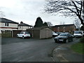
Southfield Drive, Westhoughton
A residential road.
Image: © philandju
Taken: 3 Jul 2017
0.03 miles
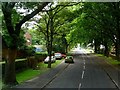
2
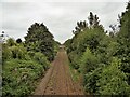
Railway towards Wigan
View of the next footbridge across the line at Daisy Hill
Image: © Kevin Waterhouse
Taken: 18 Aug 2023
0.14 miles
3
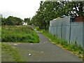
Path to The Pewfist Spinney
View from the end of Chelsea Court towards the footbridge across the railway at Daisy Hill
Image: © Kevin Waterhouse
Taken: 18 Aug 2023
0.19 miles