IMAGES TAKEN NEAR TO
Megfield, BOLTON, BL5 2JA
Introduction
This page details the photographs taken nearby to Megfield, BL5 2JA by members of the Geograph project.
The Geograph project started in 2005 with the aim of publishing, organising and preserving representative images for every square kilometre of Great Britain, Ireland and the Isle of Man.

There are currently over 7.5m images from over14,400 individuals and you can help contribute to the project by visiting https://www.geograph.org.uk
Image Map
Images are licensed for reuse under creativecommons.org/licenses/by-sa/2.0
Notes
- Clicking on the map will re-center to the selected point.
- The higher the marker number, the further away the image location is from the centre of the postcode.
Image Listing (7 Images Found)
Images are licensed for reuse under creativecommons.org/licenses/by-sa/2.0
Image
Details
Distance
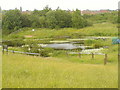
1
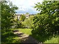
Junction of Megfield & The Hoskers from the Hill
Image: © ray blow
Taken: 29 May 2007
0.04 miles
3
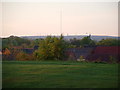
Winter hill
View of Winter Hill T.V. mast taken from top of Eatock Hill
Image: © Terry Charters
Taken: 12 May 2006
0.15 miles
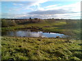
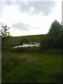
4
Path on route of former railway
Heading towards the former Eatock's Colliery this was a mineral branch line route from the Daisy Hill to Hindley main line. The site of the colliery is now a local nature reserve.
Image: © Kevin Waterhouse
Taken: 18 Aug 2023
0.15 miles
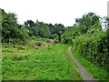
7
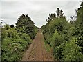
Railway towards Wigan
View of the next footbridge across the line at Daisy Hill
Image: © Kevin Waterhouse
Taken: 18 Aug 2023
0.20 miles