IMAGES TAKEN NEAR TO
Old Vicarage Mews, BOLTON, BL5 2EQ
Introduction
This page details the photographs taken nearby to Old Vicarage Mews, BL5 2EQ by members of the Geograph project.
The Geograph project started in 2005 with the aim of publishing, organising and preserving representative images for every square kilometre of Great Britain, Ireland and the Isle of Man.

There are currently over 7.5m images from over14,400 individuals and you can help contribute to the project by visiting https://www.geograph.org.uk
Image Map
Images are licensed for reuse under creativecommons.org/licenses/by-sa/2.0
Notes
- Clicking on the map will re-center to the selected point.
- The higher the marker number, the further away the image location is from the centre of the postcode.
Image Listing (11 Images Found)
Images are licensed for reuse under creativecommons.org/licenses/by-sa/2.0
Image
Details
Distance
3
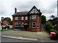
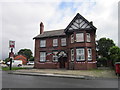
The Grey Man
A public house in a housing estate in Daisy Hill.
Image: © philandju
Taken: 3 Jul 2017
0.16 miles
4
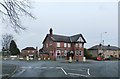
The Grey Man Public House - Daisy Hill
Image: © Anthony Parkes
Taken: 7 Jan 2016
0.16 miles
6
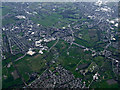
Atherton from the air
Viewed from a Manchester bound flight from Prague.
Image: © Thomas Nugent
Taken: 18 Apr 2014
0.19 miles
8
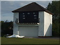
Daisy Hill Cricket Club - Scoreboard
Daisy Hill CC's scoreboard. The club play their cricket in the Bolton & District Cricket Association.
Image: © BatAndBall
Taken: 20 Jun 2012
0.23 miles
9
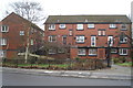
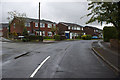
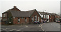
Maisonettes, Daisy Hill
Another example of the bricklayer's art.
Image: © David Long
Taken: 14 Feb 2009
0.23 miles
10
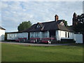
Daisy Hill Cricket Club - Pavilion
The pavilion at Daisy Hill CC's St. James Road ground.
Image: © BatAndBall
Taken: 20 Jun 2012
0.24 miles