IMAGES TAKEN NEAR TO
Wigan Road, BOLTON, BL5 2EE
Introduction
This page details the photographs taken nearby to Wigan Road, BL5 2EE by members of the Geograph project.
The Geograph project started in 2005 with the aim of publishing, organising and preserving representative images for every square kilometre of Great Britain, Ireland and the Isle of Man.

There are currently over 7.5m images from over14,400 individuals and you can help contribute to the project by visiting https://www.geograph.org.uk
Image Map
Images are licensed for reuse under creativecommons.org/licenses/by-sa/2.0
Notes
- Clicking on the map will re-center to the selected point.
- The higher the marker number, the further away the image location is from the centre of the postcode.
Image Listing (23 Images Found)
Images are licensed for reuse under creativecommons.org/licenses/by-sa/2.0
Image
Details
Distance
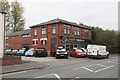
1
Coleman Milne - coachbuilders
Hearses, a dying market?
Image: © Ian Greig
Taken: 11 May 2012
0.01 miles
2
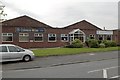
Coleman Milne Coachbuilders, Hart Common
Image: © Mark Anderson
Taken: 20 Oct 2018
0.02 miles
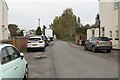
3

Emergency Ambulance on Wigan Road, Hart Common
Image: © Mark Anderson
Taken: 20 Oct 2018
0.04 miles
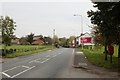
4
Public footpath sign on the A58 at Hart Common
Image: © Raymond Knapman
Taken: 3 Jun 2011
0.06 miles
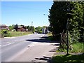
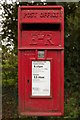
5
Chorley Road
A closer view of the postbox can be seen here: Image
Image: © Mark Anderson
Taken: 20 Oct 2018
0.08 miles
8
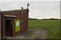
Driving Range, Hart Common Golf Course
Image: © Mark Anderson
Taken: 20 Oct 2018
0.10 miles
9
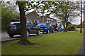
Hart Common Sports & Prestige car sales
Image: © Mark Anderson
Taken: 20 Oct 2018
0.11 miles
10
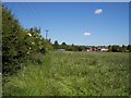
Overgrown footpath near Hart Common
The powerline and hedge mark the route followed by the path
Image: © Raymond Knapman
Taken: 3 Jun 2011
0.13 miles