IMAGES TAKEN NEAR TO
Hindley Road, BOLTON, BL5 2DS
Introduction
This page details the photographs taken nearby to Hindley Road, BL5 2DS by members of the Geograph project.
The Geograph project started in 2005 with the aim of publishing, organising and preserving representative images for every square kilometre of Great Britain, Ireland and the Isle of Man.

There are currently over 7.5m images from over14,400 individuals and you can help contribute to the project by visiting https://www.geograph.org.uk
Image Map
Images are licensed for reuse under creativecommons.org/licenses/by-sa/2.0
Notes
- Clicking on the map will re-center to the selected point.
- The higher the marker number, the further away the image location is from the centre of the postcode.
Image Listing (9 Images Found)
Images are licensed for reuse under creativecommons.org/licenses/by-sa/2.0
Image
Details
Distance
1
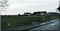
Bugle Horn Farm from Cunningham Brook
Image: © Anthony Parkes
Taken: 7 Jan 2016
0.01 miles
2
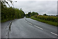
Hindley Road
Approaching The Pungle http://www.theboltonnews.co.uk/news/4804881.Project_to_get_to_the_Root_of_estate_troubles/
Image: © Ian Greig
Taken: 8 Jun 2012
0.06 miles
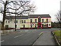
3
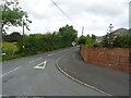
Road Junction
Wearish Lane meets Hindley Road.
Image: © philandju
Taken: 3 Jul 2017
0.08 miles
5
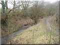
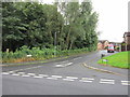
Cunningham Brook, Daisy Hill
Photo taken from a bridge on Wearish Lane.
Image: © Margaret Clough
Taken: 15 Jan 2006
0.22 miles
6

Upside down Union Flag #44
At Alder Lane Nurseries.
Image: © Ian S
Taken: 18 Jul 2012
0.23 miles

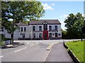
9
The Alexandra Hotel, Hindley Green
The Alexandra Hotel is on Hindley Road, opposite the junction with Alder Lane.
Image: © David Dixon
Taken: 15 Feb 2012
0.24 miles