IMAGES TAKEN NEAR TO
Rutherford Drive, BOLTON, BL5 1DL
Introduction
This page details the photographs taken nearby to Rutherford Drive, BL5 1DL by members of the Geograph project.
The Geograph project started in 2005 with the aim of publishing, organising and preserving representative images for every square kilometre of Great Britain, Ireland and the Isle of Man.

There are currently over 7.5m images from over14,400 individuals and you can help contribute to the project by visiting https://www.geograph.org.uk
Image Map
Images are licensed for reuse under creativecommons.org/licenses/by-sa/2.0
Notes
- Clicking on the map will re-center to the selected point.
- The higher the marker number, the further away the image location is from the centre of the postcode.
Image Listing (8 Images Found)
Images are licensed for reuse under creativecommons.org/licenses/by-sa/2.0
Image
Details
Distance
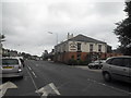
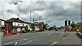
1
Row of shops on St Helens Road
These are near enough the only shops in Over Hulton.
Image: © Bill Boaden
Taken: 3 Dec 2011
0.07 miles
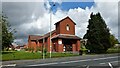
3
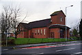
St Vincent's Church, Over Hulton
The local RC church.
Image: © Bill Boaden
Taken: 3 Dec 2011
0.10 miles
4
St Vincent de Paul Church
On Newbrook Road near Four Lane Ends
Image: © Kevin Waterhouse
Taken: 15 Aug 2023
0.11 miles
5
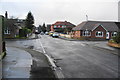
Umberton Drive
A residential road off St Helens Road. Here it is crossed by Reynolds Drive.
Image: © Bill Boaden
Taken: 3 Dec 2011
0.11 miles
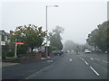
6
Newbrook Road
Approaching Four Lane Ends
Image: © Kevin Waterhouse
Taken: 15 Aug 2023
0.19 miles
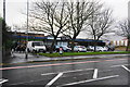
7
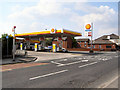
Texaco Garage
The filling station on Newbrook Road, Over Hulton, approaching the Four Lane Ends crossroads.
Image: © David Dixon
Taken: 22 May 2010
0.22 miles