IMAGES TAKEN NEAR TO
Cherry Tree Avenue, BOLTON, BL4 9SB
Introduction
This page details the photographs taken nearby to Cherry Tree Avenue, BL4 9SB by members of the Geograph project.
The Geograph project started in 2005 with the aim of publishing, organising and preserving representative images for every square kilometre of Great Britain, Ireland and the Isle of Man.

There are currently over 7.5m images from over14,400 individuals and you can help contribute to the project by visiting https://www.geograph.org.uk
Image Map (Loading...)


Getting Data...Please wait
Leaflet Map data © OpenStreetMap
Images are licensed for reuse under creativecommons.org/licenses/by-sa/2.0
Notes
- Clicking on the map will re-center to the selected point.
- The higher the marker number, the further away the image location is from the centre of the postcode.
Image Listing (16 Images Found)
Images are licensed for reuse under creativecommons.org/licenses/by-sa/2.0
Image
Details
Distance
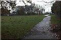
1
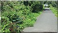
Bench and The Dell footpath
This used to be the site of Plodder Lane railway station, which has out of operation since 1954 (see https://en.wikipedia.org/wiki/Plodder_Lane_railway_station ).
Image: © Bradley Michael
Taken: 4 Sep 2015
0.05 miles
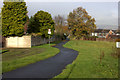
2
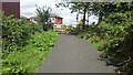
Plodder Lane entrance to The Dell
Crossing the road leads on to another path - Image - which heads towards Royal Bolton Hospital and Great Lever.
Image: © Bradley Michael
Taken: 4 Sep 2015
0.05 miles
3
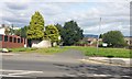
Path off Plodder Lane
The path heads towards Royal Bolton Hospital and Great Lever, and more immediately, a housing estate.
Image: © Bradley Michael
Taken: 4 Sep 2015
0.07 miles
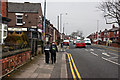
7
Route 55 path near Plodder Lane, looking north
Image: © Robert Eva
Taken: 17 Nov 2017
0.10 miles
9
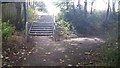
Steps to Highfield Road from The Dell
Crossing the road leads to a set of steps and then a path heading towards the M61.
Image: © Bradley Michael
Taken: 4 Sep 2015
0.13 miles
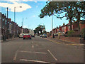
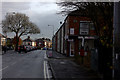
10
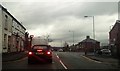
Junction at the end of Marsh Lane
Marsh Lane (near) continues onto Bradford Road and Plodder Lane is left and right. This is the busiest junction in Image, Bradford Road is a route to Bolton and Plodder Lane (B6199) links Farnworth and the M61.
Image: © Bradley Michael
Taken: 22 Dec 2015
0.14 miles