IMAGES TAKEN NEAR TO
Pear Tree Place, BOLTON, BL4 9RX
Introduction
This page details the photographs taken nearby to Pear Tree Place, BL4 9RX by members of the Geograph project.
The Geograph project started in 2005 with the aim of publishing, organising and preserving representative images for every square kilometre of Great Britain, Ireland and the Isle of Man.

There are currently over 7.5m images from over14,400 individuals and you can help contribute to the project by visiting https://www.geograph.org.uk
Image Map
Images are licensed for reuse under creativecommons.org/licenses/by-sa/2.0
Notes
- Clicking on the map will re-center to the selected point.
- The higher the marker number, the further away the image location is from the centre of the postcode.
Image Listing (20 Images Found)
Images are licensed for reuse under creativecommons.org/licenses/by-sa/2.0
Image
Details
Distance
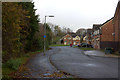
1
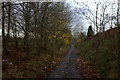
Cycle path following route of former railway
The cycle route has made a detour to cross the M61 motorway but here re-joins the railway route heading towards Bolton
Image: © Kevin Waterhouse
Taken: 12 Jun 2023
0.06 miles
2
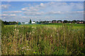
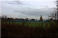
Open land at Highfield
Ahead is St James's C of E High School, which I am sure uses the visible sports facilities.
Image: © Bill Boaden
Taken: 7 Sep 2015
0.08 miles
3
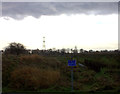
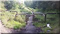
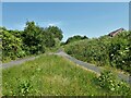
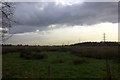
Footpath junction at Highfield
The next rain shower is on the way
Image: © Robert Eva
Taken: 17 Nov 2017
0.08 miles
6
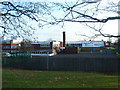
St. James C of E School and Sports College
Image: © Margaret Clough
Taken: 21 Jan 2006
0.14 miles
8
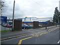
St James's CE School & Sports College
Image: © Anthony Parkes
Taken: 19 Sep 2011
0.15 miles