IMAGES TAKEN NEAR TO
Albert Road, BOLTON, BL4 9HZ
Introduction
This page details the photographs taken nearby to Albert Road, BL4 9HZ by members of the Geograph project.
The Geograph project started in 2005 with the aim of publishing, organising and preserving representative images for every square kilometre of Great Britain, Ireland and the Isle of Man.

There are currently over 7.5m images from over14,400 individuals and you can help contribute to the project by visiting https://www.geograph.org.uk
Image Map
Images are licensed for reuse under creativecommons.org/licenses/by-sa/2.0
Notes
- Clicking on the map will re-center to the selected point.
- The higher the marker number, the further away the image location is from the centre of the postcode.
Image Listing (22 Images Found)
Images are licensed for reuse under creativecommons.org/licenses/by-sa/2.0
Image
Details
Distance
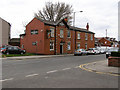
1
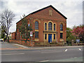
United Reformed Church
Albert Road, Farnworth
Image: © David Dixon
Taken: 2 May 2010
0.03 miles
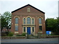
2
Farnworth United Reformed Church
Albert Road.
Image: © David Dixon
Taken: 2 May 2010
0.03 miles
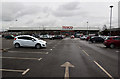
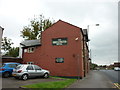
8
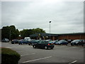
The Lidl supermarket on Albert Road, Farnworth
Image: © Ian S
Taken: 3 Sep 2011
0.12 miles
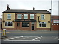
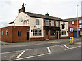
10
The Bridgewater Hotel on Buckley Lane
A Sam Smith's public house
Image: © Ian S
Taken: 3 Sep 2011
0.13 miles