IMAGES TAKEN NEAR TO
Tamar Close, BOLTON, BL4 8PY
Introduction
This page details the photographs taken nearby to Tamar Close, BL4 8PY by members of the Geograph project.
The Geograph project started in 2005 with the aim of publishing, organising and preserving representative images for every square kilometre of Great Britain, Ireland and the Isle of Man.

There are currently over 7.5m images from over14,400 individuals and you can help contribute to the project by visiting https://www.geograph.org.uk
Image Map
Images are licensed for reuse under creativecommons.org/licenses/by-sa/2.0
Notes
- Clicking on the map will re-center to the selected point.
- The higher the marker number, the further away the image location is from the centre of the postcode.
Image Listing (21 Images Found)
Images are licensed for reuse under creativecommons.org/licenses/by-sa/2.0
Image
Details
Distance
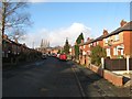
1
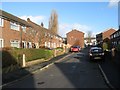
Tamar Close
Housing behind the neighbourhood shopping precinct.
Image: © Jonathan Wilkins
Taken: 26 Dec 2016
0.01 miles
2
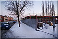
The site of a new Tesco Express on Manchester Road
Still under construction, but not necessarily good news for other outlets like the CostCutter next door.
Image: © Bill Boaden
Taken: 24 Dec 2010
0.05 miles
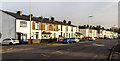
4
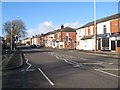
Shops, Manchester Road
Shops on the Manchester Road by the junction with Baker Street (right).
Image: © Jonathan Wilkins
Taken: 26 Dec 2016
0.06 miles
5
Calder Drive
Calder Drive on the housing estate to the south of the Manchester Road.
Image: © Jonathan Wilkins
Taken: 26 Dec 2016
0.09 miles
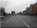
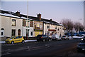
6
Manchester Road
Terraced houses on Manchester Road in Kearsley.
Image: © Peter McDermott
Taken: 7 Feb 2015
0.15 miles
7
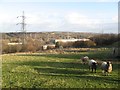
Paddock with sheep
Cross Street commands a surprisingly fine view of the Irwell valley, but I did not expect to find sheep grazing fields just yards from the Manchester Road.
Image: © Jonathan Wilkins
Taken: 26 Dec 2016
0.17 miles
8
The Spread Eagle, Manchester Road, Kearsley
Image: © Bill Boaden
Taken: 24 Dec 2010
0.18 miles
9
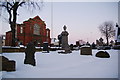
Kearsley Mount Methodist Church
Seen across the churchyard of St Stephen's Church on the opposite side of Manchester Road.
Image: © Bill Boaden
Taken: 24 Dec 2010
0.18 miles
10

Spread Eagle, Kearsley
The Spread Eagle public house at the corner of Slackey Brow and Manchester Road (A666).
Image: © David Dixon
Taken: 22 Feb 2012
0.19 miles