IMAGES TAKEN NEAR TO
Elm Road, BOLTON, BL4 8LL
Introduction
This page details the photographs taken nearby to Elm Road, BL4 8LL by members of the Geograph project.
The Geograph project started in 2005 with the aim of publishing, organising and preserving representative images for every square kilometre of Great Britain, Ireland and the Isle of Man.

There are currently over 7.5m images from over14,400 individuals and you can help contribute to the project by visiting https://www.geograph.org.uk
Image Map
Images are licensed for reuse under creativecommons.org/licenses/by-sa/2.0
Notes
- Clicking on the map will re-center to the selected point.
- The higher the marker number, the further away the image location is from the centre of the postcode.
Image Listing (7 Images Found)
Images are licensed for reuse under creativecommons.org/licenses/by-sa/2.0
Image
Details
Distance
1
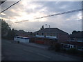
The "Spar" owned for over 30 years by John Roberts
Photo taken in the summer of 2006
Image: © Jamie Roberts
Taken: 15 Jul 2006
0.14 miles
3
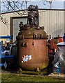
Lyon Road Industrial Estate
Reactor vessel at Chemical Reactor Services on Lyon Road Industrial Estate.
Image: © Peter McDermott
Taken: 7 Feb 2015
0.22 miles
5

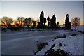
Solitary birch tree at Manor Golf Club
The snow cover made it hard to discern the golf course.
Image: © Bill Boaden
Taken: 24 Dec 2010
0.23 miles
6
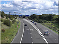
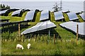
M61 at Junction 2
The link from the M61 to the clockwise M60 (Manchester Outer Ring Road) and slip road to the Manchester-bound East Lancashire Road (A580).
Image: © David Dixon
Taken: 28 Aug 2011
0.23 miles
7
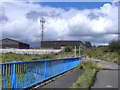
Moss Lane
Looking along Moss Lane as it crosses the M61, towards the Lion Industrial Estate.
Image: © David Dixon
Taken: 28 Aug 2011
0.25 miles