IMAGES TAKEN NEAR TO
Mossfield Road, BOLTON, BL4 8LD
Introduction
This page details the photographs taken nearby to Mossfield Road, BL4 8LD by members of the Geograph project.
The Geograph project started in 2005 with the aim of publishing, organising and preserving representative images for every square kilometre of Great Britain, Ireland and the Isle of Man.

There are currently over 7.5m images from over14,400 individuals and you can help contribute to the project by visiting https://www.geograph.org.uk
Image Map (Loading...)


Getting Data...Please wait
Leaflet Map data © OpenStreetMap
Images are licensed for reuse under creativecommons.org/licenses/by-sa/2.0
Notes
- Clicking on the map will re-center to the selected point.
- The higher the marker number, the further away the image location is from the centre of the postcode.
Image Listing (6 Images Found)
Images are licensed for reuse under creativecommons.org/licenses/by-sa/2.0
Image
Details
Distance
1
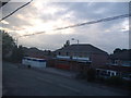
The "Spar" owned for over 30 years by John Roberts
Photo taken in the summer of 2006
Image: © Jamie Roberts
Taken: 15 Jul 2006
0.08 miles
2
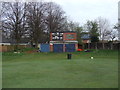
Kearsley Cricket Club - Scoreboard
The scoreboard at Kearsley CC.
Image: © BatAndBall
Taken: 3 May 2013
0.19 miles
3
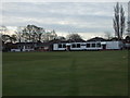
Kearsley Cricket Club - Pavilion
The Pavilion and changing rooms at Kearsley CC. The club run two teams in the Bolton Cricket League.
Image: © BatAndBall
Taken: 3 May 2013
0.21 miles
4
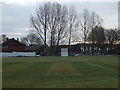
Kearsley CC - Ground
Kearsley CC's Springfield Road ground.
Image: © BatAndBall
Taken: 3 May 2013
0.23 miles
5
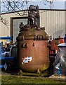
Lyon Road Industrial Estate
Reactor vessel at Chemical Reactor Services on Lyon Road Industrial Estate.
Image: © Peter McDermott
Taken: 7 Feb 2015
0.23 miles