IMAGES TAKEN NEAR TO
Hazlemere, BOLTON, BL4 8EG
Introduction
This page details the photographs taken nearby to Hazlemere, BL4 8EG by members of the Geograph project.
The Geograph project started in 2005 with the aim of publishing, organising and preserving representative images for every square kilometre of Great Britain, Ireland and the Isle of Man.

There are currently over 7.5m images from over14,400 individuals and you can help contribute to the project by visiting https://www.geograph.org.uk
Image Map
Images are licensed for reuse under creativecommons.org/licenses/by-sa/2.0
Notes
- Clicking on the map will re-center to the selected point.
- The higher the marker number, the further away the image location is from the centre of the postcode.
Image Listing (33 Images Found)
Images are licensed for reuse under creativecommons.org/licenses/by-sa/2.0
Image
Details
Distance
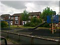
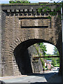
2
Railway bridges at former Kearsley Junction
Marked as a tunnel on OS maps this is a series of bridges, only the foremost still being used. The others being for a branch line and access to once extensive sidings.
Image: © Kevin Waterhouse
Taken: 26 Feb 2024
0.13 miles
3
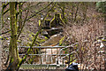
A not very pretty stream
With the benefit of a generous amount of litter it could be classed as punk
Image: © Ian Greig
Taken: 20 Feb 2015
0.14 miles
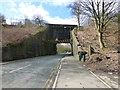
4
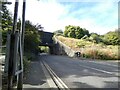
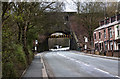
Stoneclough Road
The A667 from Whitefield passing under the Manchester to Bolton railway. Kearsley Station lies to the right of the bridge.
Image: © Gerald England
Taken: 23 Sep 2022
0.14 miles
5
Kearsley - Stoneclough Road bridge below station
For an alternative view of this bridge, please see Image
Image: © Dave Bevis
Taken: 21 May 2012
0.15 miles
6
Stoneclough Road railway bridge at Kearsley
Image: © Raymond Knapman
Taken: 4 Apr 2015
0.15 miles
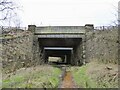
7
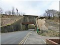
Historic railway bridge across Stoneclough Road
There appears to be movement on the bridge abutments, requiring the steel beams across the road and the embankment appears to have had some attention.
Image: © Kevin Waterhouse
Taken: 26 Feb 2024
0.15 miles
8
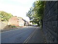
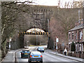
Stoneclough Road
The A667 from Kearsley to Whitefield.
Image: © Gerald England
Taken: 23 Sep 2022
0.15 miles
10
Bridge at Kearsley Station
Bridge carrying the railway over Stoneclough Road (A667). Kearsley station is to the right hand side (out of shot) on the far side of the bridge.
Image: © David Dixon
Taken: 14 Mar 2010
0.16 miles