IMAGES TAKEN NEAR TO
Bolton Road, BOLTON, BL4 8DB
Introduction
This page details the photographs taken nearby to Bolton Road, BL4 8DB by members of the Geograph project.
The Geograph project started in 2005 with the aim of publishing, organising and preserving representative images for every square kilometre of Great Britain, Ireland and the Isle of Man.

There are currently over 7.5m images from over14,400 individuals and you can help contribute to the project by visiting https://www.geograph.org.uk
Image Map (Loading...)


Getting Data...Please wait
Leaflet Map data © OpenStreetMap
Images are licensed for reuse under creativecommons.org/licenses/by-sa/2.0
Notes
- Clicking on the map will re-center to the selected point.
- The higher the marker number, the further away the image location is from the centre of the postcode.
Image Listing (31 Images Found)
Images are licensed for reuse under creativecommons.org/licenses/by-sa/2.0
Image
Details
Distance
1
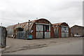
Nissen huts at Farnworth
These may well have been acquired second hand from a military site. In use here as part of a transport depot.
Image: © Alan Murray-Rust
Taken: 21 Aug 2012
0.08 miles
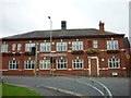
3
Farnworth and Kearsley Labour Club
At the junction of Long Causeway (A5083) and Higher Market Street (A6053).
Image: © David Dixon
Taken: 2 May 2010
0.08 miles
4
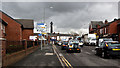
The Clock Face
Old Hall Street, Farnworth.
Image: © David Dixon
Taken: 2 May 2010
0.08 miles
5
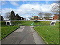
Underpass entrances at Bolton Road roundabout
The large roundabout on Bolton Road above the M61 motorway spur has this provision for pedestrians.
Image: © Kevin Waterhouse
Taken: 26 Feb 2024
0.08 miles
6
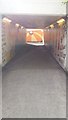
Kearsley Roundabout underpass
The wall decoration was done by a local primary school, with permission!
Image: © Bradley Michael
Taken: 24 Aug 2014
0.08 miles
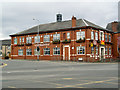
7
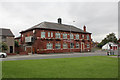
Farnworth and Kearsley Labour Club
A typical workingmen's club from the early part of the 20th century.
Image: © Alan Murray-Rust
Taken: 21 Aug 2012
0.08 miles
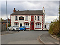
8
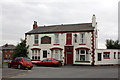
The Clock Face at Kearsley
The name Clock Face appears on the first edition of the OS 6-inch maps, but it's not clear whether this refers to the pub or a pre-existing location name.
Image: © Alan Murray-Rust
Taken: 21 Aug 2012
0.09 miles
10
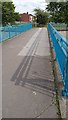
Footbridge at Kearsley Roundabout
The pavements of Bolton Road do not stay with the road. They continue as tunnels (like the one in the top-left) and all meet on a bridge over where the A666 and M61 meet.
Image: © Bradley Michael
Taken: 24 Aug 2014
0.10 miles