IMAGES TAKEN NEAR TO
Alfred Street, BOLTON, BL4 8BU
Introduction
This page details the photographs taken nearby to Alfred Street, BL4 8BU by members of the Geograph project.
The Geograph project started in 2005 with the aim of publishing, organising and preserving representative images for every square kilometre of Great Britain, Ireland and the Isle of Man.

There are currently over 7.5m images from over14,400 individuals and you can help contribute to the project by visiting https://www.geograph.org.uk
Image Map
Images are licensed for reuse under creativecommons.org/licenses/by-sa/2.0
Notes
- Clicking on the map will re-center to the selected point.
- The higher the marker number, the further away the image location is from the centre of the postcode.
Image Listing (14 Images Found)
Images are licensed for reuse under creativecommons.org/licenses/by-sa/2.0
Image
Details
Distance
1
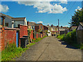
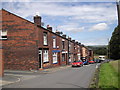
Back Church Rd
The back street & garages of Church Rd
Image: © N Houghton
Taken: 8 Aug 2007
0.10 miles
2
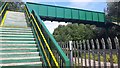
Bridge over the railway, Kearsley
The bridge was constructed in 2015 as part of the work on the Preston to Manchester railway line. It was previously a pedestrian level crossing.
Image: © Bradley Michael
Taken: 31 Jul 2015
0.11 miles
3
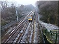
Bolton-bound train on a frosty afternoon
Image: © Bradley Michael
Taken: 9 Dec 2022
0.12 miles
4
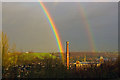
Double Rainbow Over Kearsley Mill
Taken from Church Rd Kearsley just as the sun broke through rain clouds. The chimney stack was under repair some 15-18 years ago when a lot of damage was done to the safety equipment during a storm. Tarpaulins blew away & planks of wood were left dangling.
Image: © N Houghton
Taken: 17 Jan 2008
0.20 miles
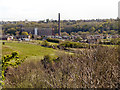
5
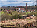
Prestolee
A view from Prestolee Road, looking across the disused Nob End/Prestolee Locks and the Prestolee Aqueduct, towards Kearsley Mill.
Image: © David Dixon
Taken: 30 Jan 2021
0.20 miles
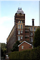
7
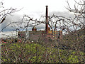
Prestolee/Kearsley Mill
This Grade II listed mill, at Prestolee, was built in 1906.
Image: © David Dixon
Taken: 14 Nov 2010
0.22 miles
8
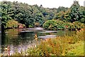
River Irwell
Confluence of The River Irwell and the River Croal.
Image: © Edward Smith
Taken: Unknown
0.22 miles
9
Kearsley Mill - Stoneclough
Household textiles are still manufactured in Kearsley Mill.
Image: © David Harris
Taken: 25 Mar 2004
0.22 miles
10
Prestolee (Kearsley) Mill
A view looking toward Prestolee Mill, also known as Kearsley Mill, from the Meccano Bridge (Image]) over the Manchester, Bolton and Bury Canal at Nob End. The mill was built in 1906, and has Grade II listed status.
Image: © David Dixon
Taken: 4 May 2013
0.23 miles