IMAGES TAKEN NEAR TO
Sandridge Close, BOLTON, BL4 8AZ
Introduction
This page details the photographs taken nearby to Sandridge Close, BL4 8AZ by members of the Geograph project.
The Geograph project started in 2005 with the aim of publishing, organising and preserving representative images for every square kilometre of Great Britain, Ireland and the Isle of Man.

There are currently over 7.5m images from over14,400 individuals and you can help contribute to the project by visiting https://www.geograph.org.uk
Image Map (Loading...)


Getting Data...Please wait
Leaflet Map data © OpenStreetMap
Images are licensed for reuse under creativecommons.org/licenses/by-sa/2.0
Notes
- Clicking on the map will re-center to the selected point.
- The higher the marker number, the further away the image location is from the centre of the postcode.
Image Listing (51 Images Found)
Images are licensed for reuse under creativecommons.org/licenses/by-sa/2.0
Image
Details
Distance
1
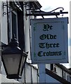
Sign of Ye Olde Three Crowns
Sign for Ye Olde Three Crowns Image
Image: © Gerald England
Taken: 23 Sep 2022
0.07 miles
2
Ye Olde Three Crowns
Image: © Gerald England
Taken: 23 Sep 2022
0.07 miles
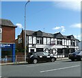
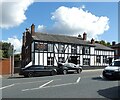
3
Ye Olde Three Crowns
27 Higher Market Street, Farnworth, Bolton.
Image: © David Dixon
Taken: 2 May 2010
0.08 miles
4
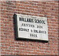
Hollands School: Plaque
The plaque on Hollands School Image reads:
HOLLANDS SCHOOL
ERECTED, 1810.
REBUILT & ENLARGED
1868.
Image: © Gerald England
Taken: 23 Sep 2022
0.09 miles
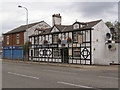
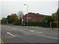
5
Hollands School
Former school Image, now a nursing home on Higher Market Street (A6053). The road forms the boundary between Kearsley (on the left) and Farnworth (on the right).
Image: © Gerald England
Taken: 23 Sep 2022
0.09 miles
6
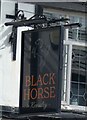
Sign of the Black Horse
Sign for the Black Horse Image
Image: © Gerald England
Taken: 23 Sep 2022
0.09 miles
8
Farnworth, Holland's School
On Manchester Road; a plaque states that the building was erected in 1810, and rebuilt in 1868. Now a nursing home.
Image: © Mike Faherty
Taken: 18 Oct 2009
0.10 miles
9
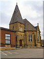
Trinity Church
The church on the corner of Church Road and Presto Street is now incorporated into Trinity Church and appears to be being used as a Sunday School.
Image: © David Dixon
Taken: 2 May 2010
0.10 miles
10
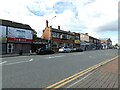
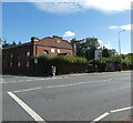
Higher Market Street
The A6053 through Kearsley and Farnworth.
Image: © Gerald England
Taken: 23 Sep 2022
0.10 miles